You are here: Home > Network List > GS - US Geological Survey Networks Stations List
> Station OK051 E0350 and S34600 roads, Ralston OK > Earthquake Result Viewer
OK051 E0350 and S34600 roads, Ralston OK - Earthquake Result Viewer
| Earthquake location: |
Kuril Islands |
| Earthquake latitude/longitude: |
48.8/155.0 |
| Earthquake time(UTC): |
2021/08/24 (236) 05:37:51 GMT |
| Earthquake Depth: |
31 km |
| Earthquake Magnitude: |
6.0 mww |
| Earthquake Catalog/Contributor: |
NEIC PDE/us |
|
| Network: |
GS US Geological Survey Networks |
| Station: |
OK051 E0350 and S34600 roads, Ralston OK |
| Lat/Lon: |
36.50 N/96.84 W |
| Elevation: |
263 m |
|
| Distance: |
73.9 deg |
| Az: |
52.824 deg |
| Baz: |
319.181 deg |
| Ray Param: |
0.052692693 |
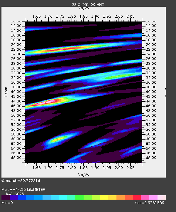
| Estimated Moho Depth: |
44.25 km |
| Estimated Crust Vp/Vs: |
1.69 |
| Assumed Crust Vp: |
6.483 km/s |
| Estimated Crust Vs: |
3.842 km/s |
| Estimated Crust Poisson's Ratio: |
0.23 |
|
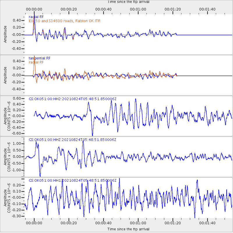
| Radial Match: |
80.772316 % |
| Radial Bump: |
383 |
| Transverse Match: |
60.786873 % |
| Transverse Bump: |
400 |
| SOD ConfigId: |
25131211 |
| Insert Time: |
2021-09-07 05:53:46.135 +0000 |
| GWidth: |
2.5 |
| Max Bumps: |
400 |
| Tol: |
0.001 |
|
Signal To Noise
| Channel | StoN | STA | LTA |
| GS:OK051:00:HHZ:20210824T05:48:51.850006Z | 12.5524845 | 7.488003E-7 | 5.965355E-8 |
| GS:OK051:00:HH1:20210824T05:48:51.850006Z | 1.706717 | 1.195133E-7 | 7.002526E-8 |
| GS:OK051:00:HH2:20210824T05:48:51.850006Z | 5.6421156 | 3.0321303E-7 | 5.3741022E-8 |
| Arrivals |
| Ps | 4.9 SECOND |
| PpPs | 18 SECOND |
| PsPs/PpSs | 23 SECOND |


