You are here: Home > Network List > MB - Montana Regional Seismic Network Stations List
> Station GBMT Granite Butte > Earthquake Result Viewer
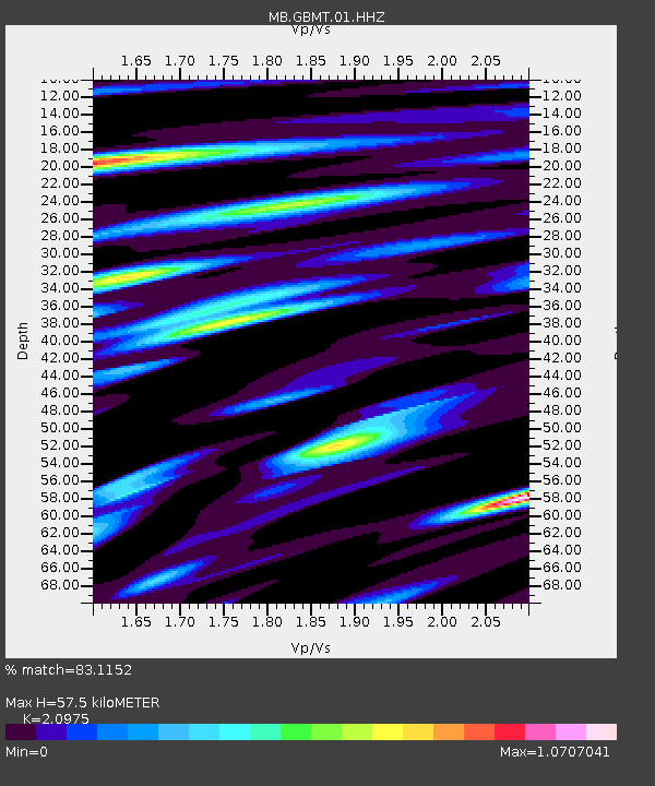
GBMT Granite Butte - Earthquake Result Viewer
| Earthquake location: |
Kuril Islands |
| Earthquake latitude/longitude: |
48.8/155.0 |
| Earthquake time(UTC): |
2021/08/24 (236) 05:37:51 GMT |
| Earthquake Depth: |
31 km |
| Earthquake Magnitude: |
6.0 mww |
| Earthquake Catalog/Contributor: |
NEIC PDE/us |
|
| Network: |
MB Montana Regional Seismic Network |
| Station: |
GBMT Granite Butte |
| Lat/Lon: |
46.86 N/112.46 W |
| Elevation: |
2248 m |
|
| Distance: |
58.3 deg |
| Az: |
53.675 deg |
| Baz: |
309.101 deg |
| Ray Param: |
0.06287164 |
| Estimated Moho Depth: |
57.5 km |
| Estimated Crust Vp/Vs: |
2.10 |
| Assumed Crust Vp: |
6.353 km/s |
| Estimated Crust Vs: |
3.029 km/s |
| Estimated Crust Poisson's Ratio: |
0.35 |
|
| Radial Match: |
83.1152 % |
| Radial Bump: |
400 |
| Transverse Match: |
79.9074 % |
| Transverse Bump: |
400 |
| SOD ConfigId: |
25131211 |
| Insert Time: |
2021-09-07 05:56:50.482 +0000 |
| GWidth: |
2.5 |
| Max Bumps: |
400 |
| Tol: |
0.001 |
|

Signal To Noise
| Channel | StoN | STA | LTA |
| MB:GBMT:01:HHZ:20210824T05:47:12.279999Z | 9.980748 | 7.453103E-7 | 7.467479E-8 |
| MB:GBMT:01:HHN:20210824T05:47:12.279999Z | 5.985747 | 3.4969446E-7 | 5.8421193E-8 |
| MB:GBMT:01:HHE:20210824T05:47:12.279999Z | 4.020728 | 3.7159882E-7 | 9.242078E-8 |
| Arrivals |
| Ps | 10 SECOND |
| PpPs | 27 SECOND |
| PsPs/PpSs | 37 SECOND |


