You are here: Home > Network List > MG - Seismic Network of the NorthEastern Mexico Stations List
> Station TXMV CEIEPAA, FMVZ, UNAM, Tequisquiapan, Queretaro, MEXICO > Earthquake Result Viewer
TXMV CEIEPAA, FMVZ, UNAM, Tequisquiapan, Queretaro, MEXICO - Earthquake Result Viewer
| Earthquake location: |
Kuril Islands |
| Earthquake latitude/longitude: |
48.8/155.0 |
| Earthquake time(UTC): |
2021/08/24 (236) 05:37:51 GMT |
| Earthquake Depth: |
31 km |
| Earthquake Magnitude: |
6.0 mww |
| Earthquake Catalog/Contributor: |
NEIC PDE/us |
|
| Network: |
MG Seismic Network of the NorthEastern Mexico |
| Station: |
TXMV CEIEPAA, FMVZ, UNAM, Tequisquiapan, Queretaro, MEXICO |
| Lat/Lon: |
20.61 N/99.93 W |
| Elevation: |
1908 m |
|
| Distance: |
84.2 deg |
| Az: |
65.371 deg |
| Baz: |
320.102 deg |
| Ray Param: |
0.045617376 |
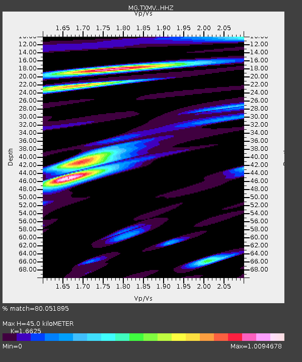
| Estimated Moho Depth: |
45.0 km |
| Estimated Crust Vp/Vs: |
1.66 |
| Assumed Crust Vp: |
6.466 km/s |
| Estimated Crust Vs: |
3.889 km/s |
| Estimated Crust Poisson's Ratio: |
0.22 |
|
| Radial Match: |
80.051895 % |
| Radial Bump: |
400 |
| Transverse Match: |
74.8326 % |
| Transverse Bump: |
400 |
| SOD ConfigId: |
25131211 |
| Insert Time: |
2021-09-07 05:56:58.538 +0000 |
| GWidth: |
2.5 |
| Max Bumps: |
400 |
| Tol: |
0.001 |
|

Signal To Noise
| Channel | StoN | STA | LTA |
| MG:TXMV: :HHZ:20210824T05:49:48.219025Z | 6.7452126 | 1.7095908E-7 | 2.5345248E-8 |
| MG:TXMV: :HHN:20210824T05:49:48.219025Z | 1.9836059 | 3.9919097E-8 | 2.012451E-8 |
| MG:TXMV: :HHE:20210824T05:49:48.219025Z | 2.7783473 | 5.7945005E-8 | 2.0855927E-8 |
| Arrivals |
| Ps | 4.7 SECOND |
| PpPs | 18 SECOND |
| PsPs/PpSs | 23 SECOND |


