You are here: Home > Network List > N4 - Central and EAstern US Network Stations List
> Station MSTX Muleshoe, TX, USA > Earthquake Result Viewer
MSTX Muleshoe, TX, USA - Earthquake Result Viewer
| Earthquake location: |
Kuril Islands |
| Earthquake latitude/longitude: |
48.8/155.0 |
| Earthquake time(UTC): |
2021/08/24 (236) 05:37:51 GMT |
| Earthquake Depth: |
31 km |
| Earthquake Magnitude: |
6.0 mww |
| Earthquake Catalog/Contributor: |
NEIC PDE/us |
|
| Network: |
N4 Central and EAstern US Network |
| Station: |
MSTX Muleshoe, TX, USA |
| Lat/Lon: |
33.97 N/102.77 W |
| Elevation: |
1167 m |
|
| Distance: |
72.5 deg |
| Az: |
58.37 deg |
| Baz: |
317.374 deg |
| Ray Param: |
0.05358241 |
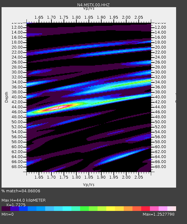
| Estimated Moho Depth: |
44.0 km |
| Estimated Crust Vp/Vs: |
1.73 |
| Assumed Crust Vp: |
6.129 km/s |
| Estimated Crust Vs: |
3.548 km/s |
| Estimated Crust Poisson's Ratio: |
0.25 |
|
| Radial Match: |
84.86806 % |
| Radial Bump: |
385 |
| Transverse Match: |
60.72869 % |
| Transverse Bump: |
400 |
| SOD ConfigId: |
25131211 |
| Insert Time: |
2021-09-07 05:58:31.645 +0000 |
| GWidth: |
2.5 |
| Max Bumps: |
400 |
| Tol: |
0.001 |
|

Signal To Noise
| Channel | StoN | STA | LTA |
| N4:MSTX:00:HHZ:20210824T05:48:43.910004Z | 12.112186 | 8.703782E-7 | 7.185971E-8 |
| N4:MSTX:00:HH1:20210824T05:48:43.910004Z | 2.6721687 | 3.2395363E-7 | 1.2123247E-7 |
| N4:MSTX:00:HH2:20210824T05:48:43.910004Z | 2.7744966 | 1.980518E-7 | 7.138297E-8 |
| Arrivals |
| Ps | 5.4 SECOND |
| PpPs | 19 SECOND |
| PsPs/PpSs | 24 SECOND |


