You are here: Home > Network List > OH - Ohio Seismic Network Stations List
> Station CPOH Chapparal Prarie > Earthquake Result Viewer
CPOH Chapparal Prarie - Earthquake Result Viewer
| Earthquake location: |
Kuril Islands |
| Earthquake latitude/longitude: |
48.8/155.0 |
| Earthquake time(UTC): |
2021/08/24 (236) 05:37:51 GMT |
| Earthquake Depth: |
31 km |
| Earthquake Magnitude: |
6.0 mww |
| Earthquake Catalog/Contributor: |
NEIC PDE/us |
|
| Network: |
OH Ohio Seismic Network |
| Station: |
CPOH Chapparal Prarie |
| Lat/Lon: |
38.84 N/83.58 W |
| Elevation: |
289 m |
|
| Distance: |
78.5 deg |
| Az: |
42.823 deg |
| Baz: |
324.878 deg |
| Ray Param: |
0.04955324 |
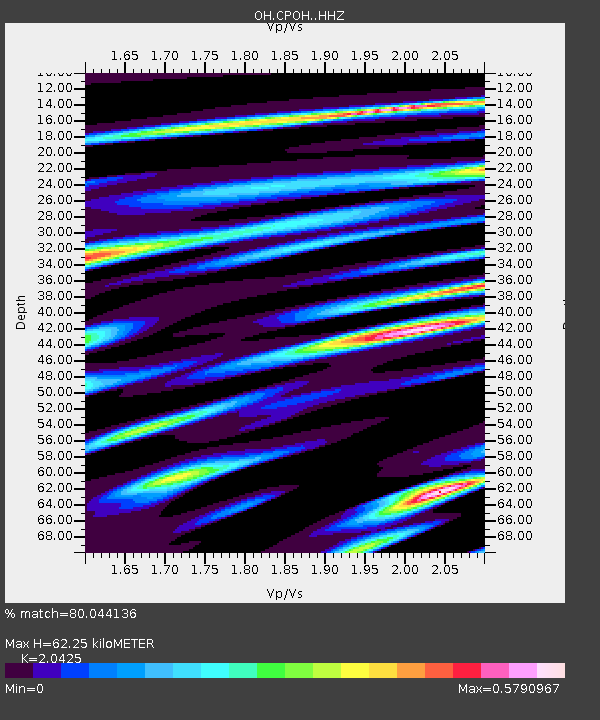
| Estimated Moho Depth: |
62.25 km |
| Estimated Crust Vp/Vs: |
2.04 |
| Assumed Crust Vp: |
6.232 km/s |
| Estimated Crust Vs: |
3.051 km/s |
| Estimated Crust Poisson's Ratio: |
0.34 |
|
| Radial Match: |
80.044136 % |
| Radial Bump: |
270 |
| Transverse Match: |
58.414425 % |
| Transverse Bump: |
358 |
| SOD ConfigId: |
25131211 |
| Insert Time: |
2021-09-07 06:03:06.974 +0000 |
| GWidth: |
2.5 |
| Max Bumps: |
400 |
| Tol: |
0.001 |
|

Signal To Noise
| Channel | StoN | STA | LTA |
| OH:CPOH: :HHZ:20210824T05:49:18.209992Z | 12.886823 | 3.208596E-8 | 2.489827E-9 |
| OH:CPOH: :HHN:20210824T05:49:18.209992Z | 8.140893 | 1.4253117E-8 | 1.7508051E-9 |
| OH:CPOH: :HHE:20210824T05:49:18.209992Z | 1.8486838 | 6.6745995E-9 | 3.6104604E-9 |
| Arrivals |
| Ps | 11 SECOND |
| PpPs | 30 SECOND |
| PsPs/PpSs | 40 SECOND |


