You are here: Home > Network List > PE - Penn State Network Stations List
> Station PSRS Rock Springs Meteorological site, Rock Springs, PA > Earthquake Result Viewer
PSRS Rock Springs Meteorological site, Rock Springs, PA - Earthquake Result Viewer
| Earthquake location: |
Kuril Islands |
| Earthquake latitude/longitude: |
48.8/155.0 |
| Earthquake time(UTC): |
2021/08/24 (236) 05:37:51 GMT |
| Earthquake Depth: |
31 km |
| Earthquake Magnitude: |
6.0 mww |
| Earthquake Catalog/Contributor: |
NEIC PDE/us |
|
| Network: |
PE Penn State Network |
| Station: |
PSRS Rock Springs Meteorological site, Rock Springs, PA |
| Lat/Lon: |
40.72 N/77.93 W |
| Elevation: |
370 m |
|
| Distance: |
79.4 deg |
| Az: |
38.076 deg |
| Baz: |
327.566 deg |
| Ray Param: |
0.048973665 |
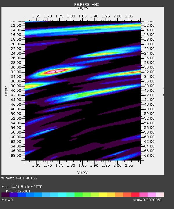
| Estimated Moho Depth: |
31.5 km |
| Estimated Crust Vp/Vs: |
1.73 |
| Assumed Crust Vp: |
6.121 km/s |
| Estimated Crust Vs: |
3.533 km/s |
| Estimated Crust Poisson's Ratio: |
0.25 |
|
| Radial Match: |
81.40162 % |
| Radial Bump: |
400 |
| Transverse Match: |
64.36648 % |
| Transverse Bump: |
400 |
| SOD ConfigId: |
25131211 |
| Insert Time: |
2021-09-07 06:04:34.970 +0000 |
| GWidth: |
2.5 |
| Max Bumps: |
400 |
| Tol: |
0.001 |
|

Signal To Noise
| Channel | StoN | STA | LTA |
| PE:PSRS: :HHZ:20210824T05:49:22.904999Z | 8.481776 | 1.0767704E-6 | 1.2695106E-7 |
| PE:PSRS: :HHN:20210824T05:49:22.904999Z | 3.045149 | 3.3429455E-7 | 1.0977937E-7 |
| PE:PSRS: :HHE:20210824T05:49:22.904999Z | 3.7011962 | 3.016805E-7 | 8.1508915E-8 |
| Arrivals |
| Ps | 3.9 SECOND |
| PpPs | 14 SECOND |
| PsPs/PpSs | 18 SECOND |


