You are here: Home > Network List > IU - Global Seismograph Network (GSN - IRIS/USGS) Stations List
> Station PMG Port Moresby, New Guinea > Earthquake Result Viewer
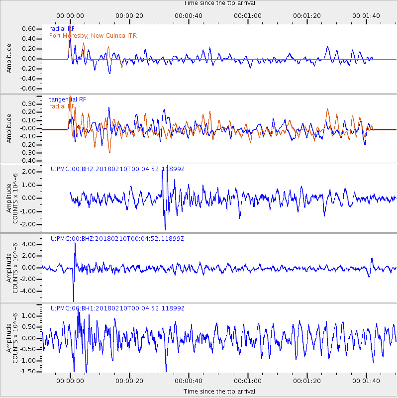
PMG Port Moresby, New Guinea - Earthquake Result Viewer
*The percent match for this event was below the threshold and hence no stack was calculated.
| Earthquake location: |
Fiji Islands Region |
| Earthquake latitude/longitude: |
-21.4/-179.3 |
| Earthquake time(UTC): |
2018/02/09 (040) 23:59:24 GMT |
| Earthquake Depth: |
610 km |
| Earthquake Magnitude: |
5.6 Mww |
| Earthquake Catalog/Contributor: |
NEIC PDE/us |
|
| Network: |
IU Global Seismograph Network (GSN - IRIS/USGS) |
| Station: |
PMG Port Moresby, New Guinea |
| Lat/Lon: |
9.40 S/147.16 E |
| Elevation: |
90 m |
|
| Distance: |
34.4 deg |
| Az: |
285.133 deg |
| Baz: |
114.276 deg |
| Ray Param: |
$rayparam |
*The percent match for this event was below the threshold and hence was not used in the summary stack. |
|
| Radial Match: |
57.532425 % |
| Radial Bump: |
400 |
| Transverse Match: |
47.87277 % |
| Transverse Bump: |
400 |
| SOD ConfigId: |
2546091 |
| Insert Time: |
2018-02-24 00:00:44.522 +0000 |
| GWidth: |
2.5 |
| Max Bumps: |
400 |
| Tol: |
0.001 |
|
Signal To Noise
| Channel | StoN | STA | LTA |
| IU:PMG:00:BHZ:20180210T00:04:52.11899Z | 4.5549226 | 1.5403826E-6 | 3.3817977E-7 |
| IU:PMG:00:BH1:20180210T00:04:52.11899Z | 1.6115973 | 6.182273E-7 | 3.8361154E-7 |
| IU:PMG:00:BH2:20180210T00:04:52.11899Z | 2.8011482 | 9.491598E-7 | 3.388467E-7 |
| Arrivals |
| Ps | |
| PpPs | |
| PsPs/PpSs | |


