You are here: Home > Network List > TD - TransAlta Monitoring Network Stations List
> Station TD007 Z > Earthquake Result Viewer
TD007 Z - Earthquake Result Viewer
| Earthquake location: |
Kuril Islands |
| Earthquake latitude/longitude: |
48.8/155.0 |
| Earthquake time(UTC): |
2021/08/24 (236) 05:37:51 GMT |
| Earthquake Depth: |
31 km |
| Earthquake Magnitude: |
6.0 mww |
| Earthquake Catalog/Contributor: |
NEIC PDE/us |
|
| Network: |
TD TransAlta Monitoring Network |
| Station: |
TD007 Z |
| Lat/Lon: |
52.91 N/115.62 W |
| Elevation: |
988 m |
|
| Distance: |
53.1 deg |
| Az: |
49.275 deg |
| Baz: |
304.204 deg |
| Ray Param: |
0.06631453 |
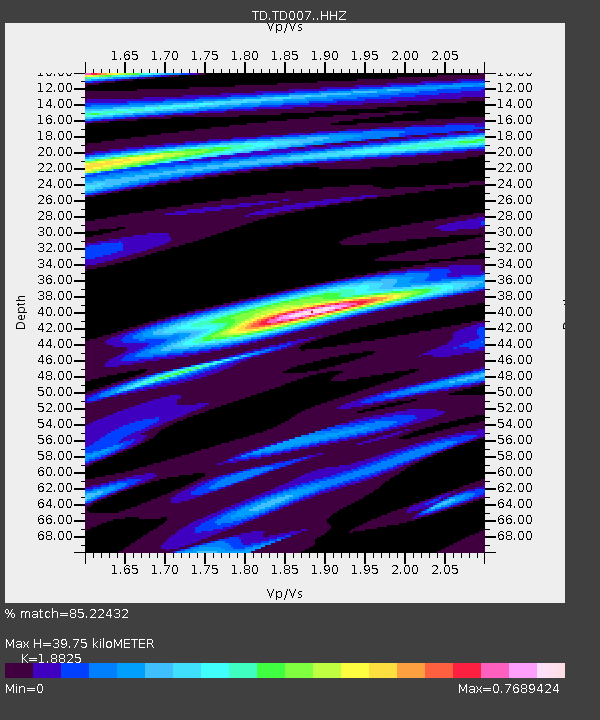
| Estimated Moho Depth: |
39.75 km |
| Estimated Crust Vp/Vs: |
1.88 |
| Assumed Crust Vp: |
6.426 km/s |
| Estimated Crust Vs: |
3.414 km/s |
| Estimated Crust Poisson's Ratio: |
0.30 |
|
| Radial Match: |
85.22432 % |
| Radial Bump: |
400 |
| Transverse Match: |
75.3168 % |
| Transverse Bump: |
400 |
| SOD ConfigId: |
25131211 |
| Insert Time: |
2021-09-07 06:07:03.859 +0000 |
| GWidth: |
2.5 |
| Max Bumps: |
400 |
| Tol: |
0.001 |
|

Signal To Noise
| Channel | StoN | STA | LTA |
| TD:TD007: :HHZ:20210824T05:46:34.649994Z | 13.904935 | 1.1397856E-6 | 8.196986E-8 |
| TD:TD007: :HH1:20210824T05:46:34.649994Z | 2.806773 | 3.0614703E-7 | 1.0907438E-7 |
| TD:TD007: :HH2:20210824T05:46:34.649994Z | 3.5034018 | 3.707977E-7 | 1.05839334E-7 |
| Arrivals |
| Ps | 5.7 SECOND |
| PpPs | 17 SECOND |
| PsPs/PpSs | 23 SECOND |


