You are here: Home > Network List > TX - Texas Seismological Network Stations List
> Station BRDY Brady > Earthquake Result Viewer
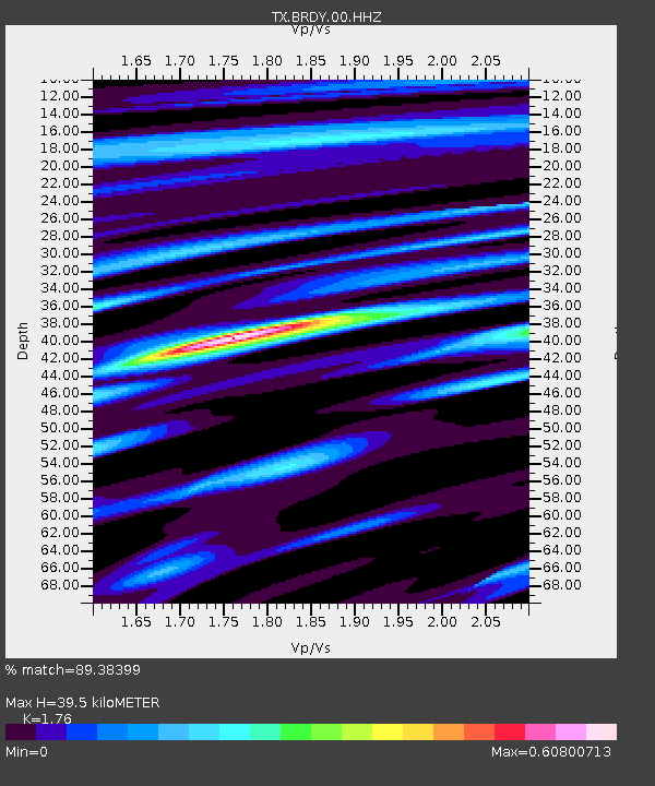
BRDY Brady - Earthquake Result Viewer
| Earthquake location: |
Kuril Islands |
| Earthquake latitude/longitude: |
48.8/155.0 |
| Earthquake time(UTC): |
2021/08/24 (236) 05:37:51 GMT |
| Earthquake Depth: |
31 km |
| Earthquake Magnitude: |
6.0 mww |
| Earthquake Catalog/Contributor: |
NEIC PDE/us |
|
| Network: |
TX Texas Seismological Network |
| Station: |
BRDY Brady |
| Lat/Lon: |
31.27 N/99.00 W |
| Elevation: |
460 m |
|
| Distance: |
76.6 deg |
| Az: |
57.764 deg |
| Baz: |
319.235 deg |
| Ray Param: |
0.05082906 |
| Estimated Moho Depth: |
39.5 km |
| Estimated Crust Vp/Vs: |
1.76 |
| Assumed Crust Vp: |
6.498 km/s |
| Estimated Crust Vs: |
3.692 km/s |
| Estimated Crust Poisson's Ratio: |
0.26 |
|
| Radial Match: |
89.38399 % |
| Radial Bump: |
315 |
| Transverse Match: |
70.457 % |
| Transverse Bump: |
400 |
| SOD ConfigId: |
25131211 |
| Insert Time: |
2021-09-07 06:07:24.973 +0000 |
| GWidth: |
2.5 |
| Max Bumps: |
400 |
| Tol: |
0.001 |
|

Signal To Noise
| Channel | StoN | STA | LTA |
| TX:BRDY:00:HHZ:20210824T05:49:07.714997Z | 17.558273 | 9.0959037E-7 | 5.180409E-8 |
| TX:BRDY:00:HH1:20210824T05:49:07.714997Z | 3.3907585 | 1.748204E-7 | 5.1557905E-8 |
| TX:BRDY:00:HH2:20210824T05:49:07.714997Z | 5.095565 | 2.3385839E-7 | 4.58945E-8 |
| Arrivals |
| Ps | 4.8 SECOND |
| PpPs | 16 SECOND |
| PsPs/PpSs | 21 SECOND |


