You are here: Home > Network List > TX - Texas Seismological Network Stations List
> Station EF04 Eagle Ford 04 > Earthquake Result Viewer
EF04 Eagle Ford 04 - Earthquake Result Viewer
| Earthquake location: |
Kuril Islands |
| Earthquake latitude/longitude: |
48.8/155.0 |
| Earthquake time(UTC): |
2021/08/24 (236) 05:37:51 GMT |
| Earthquake Depth: |
31 km |
| Earthquake Magnitude: |
6.0 mww |
| Earthquake Catalog/Contributor: |
NEIC PDE/us |
|
| Network: |
TX Texas Seismological Network |
| Station: |
EF04 Eagle Ford 04 |
| Lat/Lon: |
29.21 N/97.79 W |
| Elevation: |
116 m |
|
| Distance: |
78.9 deg |
| Az: |
58.306 deg |
| Baz: |
319.959 deg |
| Ray Param: |
0.049305305 |
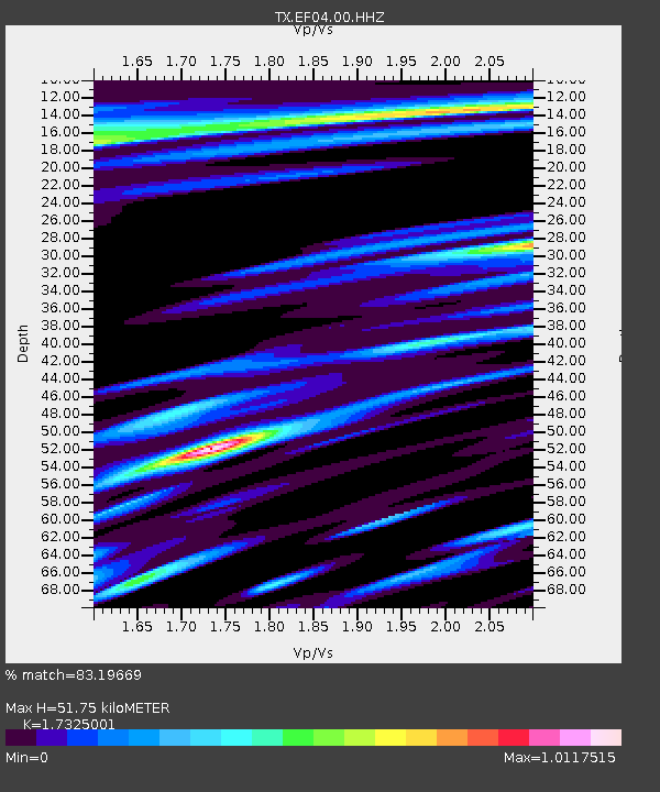
| Estimated Moho Depth: |
51.75 km |
| Estimated Crust Vp/Vs: |
1.73 |
| Assumed Crust Vp: |
5.78 km/s |
| Estimated Crust Vs: |
3.336 km/s |
| Estimated Crust Poisson's Ratio: |
0.25 |
|
| Radial Match: |
83.19669 % |
| Radial Bump: |
400 |
| Transverse Match: |
75.19649 % |
| Transverse Bump: |
400 |
| SOD ConfigId: |
25131211 |
| Insert Time: |
2021-09-07 06:07:31.630 +0000 |
| GWidth: |
2.5 |
| Max Bumps: |
400 |
| Tol: |
0.001 |
|

Signal To Noise
| Channel | StoN | STA | LTA |
| TX:EF04:00:HHZ:20210824T05:49:20.230011Z | 10.608683 | 1.0099556E-6 | 9.520084E-8 |
| TX:EF04:00:HH1:20210824T05:49:20.230011Z | 1.59132 | 1.8426778E-7 | 1.15795544E-7 |
| TX:EF04:00:HH2:20210824T05:49:20.230011Z | 2.3206687 | 2.1204173E-7 | 9.137096E-8 |
| Arrivals |
| Ps | 6.7 SECOND |
| PpPs | 24 SECOND |
| PsPs/PpSs | 31 SECOND |


