You are here: Home > Network List > TX - Texas Seismological Network Stations List
> Station MB01 Midkiff > Earthquake Result Viewer
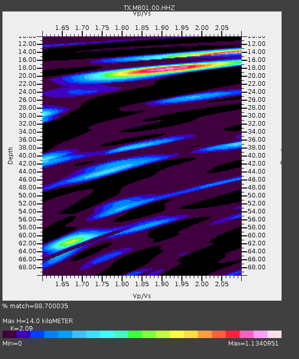
MB01 Midkiff - Earthquake Result Viewer
| Earthquake location: |
Kuril Islands |
| Earthquake latitude/longitude: |
48.8/155.0 |
| Earthquake time(UTC): |
2021/08/24 (236) 05:37:51 GMT |
| Earthquake Depth: |
31 km |
| Earthquake Magnitude: |
6.0 mww |
| Earthquake Catalog/Contributor: |
NEIC PDE/us |
|
| Network: |
TX Texas Seismological Network |
| Station: |
MB01 Midkiff |
| Lat/Lon: |
31.67 N/102.08 W |
| Elevation: |
859 m |
|
| Distance: |
74.6 deg |
| Az: |
59.532 deg |
| Baz: |
318.075 deg |
| Ray Param: |
0.052191433 |
| Estimated Moho Depth: |
14.0 km |
| Estimated Crust Vp/Vs: |
2.09 |
| Assumed Crust Vp: |
6.121 km/s |
| Estimated Crust Vs: |
2.928 km/s |
| Estimated Crust Poisson's Ratio: |
0.35 |
|
| Radial Match: |
88.700035 % |
| Radial Bump: |
400 |
| Transverse Match: |
70.849945 % |
| Transverse Bump: |
400 |
| SOD ConfigId: |
25131211 |
| Insert Time: |
2021-09-07 06:07:55.161 +0000 |
| GWidth: |
2.5 |
| Max Bumps: |
400 |
| Tol: |
0.001 |
|

Signal To Noise
| Channel | StoN | STA | LTA |
| TX:MB01:00:HHZ:20210824T05:48:56.149994Z | 11.214093 | 5.7839E-7 | 5.1577064E-8 |
| TX:MB01:00:HH1:20210824T05:48:56.149994Z | 3.395124 | 1.400693E-7 | 4.125602E-8 |
| TX:MB01:00:HH2:20210824T05:48:56.149994Z | 4.0293465 | 1.3873948E-7 | 3.4432254E-8 |
| Arrivals |
| Ps | 2.6 SECOND |
| PpPs | 6.9 SECOND |
| PsPs/PpSs | 9.4 SECOND |


