You are here: Home > Network List > TX - Texas Seismological Network Stations List
> Station RTBA Rita Blanca > Earthquake Result Viewer
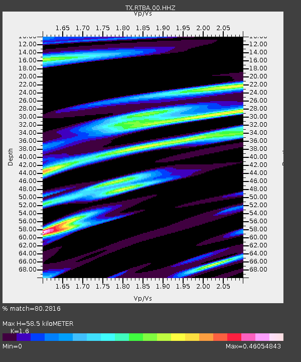
RTBA Rita Blanca - Earthquake Result Viewer
| Earthquake location: |
Kuril Islands |
| Earthquake latitude/longitude: |
48.8/155.0 |
| Earthquake time(UTC): |
2021/08/24 (236) 05:37:51 GMT |
| Earthquake Depth: |
31 km |
| Earthquake Magnitude: |
6.0 mww |
| Earthquake Catalog/Contributor: |
NEIC PDE/us |
|
| Network: |
TX Texas Seismological Network |
| Station: |
RTBA Rita Blanca |
| Lat/Lon: |
36.44 N/102.74 W |
| Elevation: |
1284 m |
|
| Distance: |
70.7 deg |
| Az: |
56.582 deg |
| Baz: |
316.83 deg |
| Ray Param: |
0.0547597 |
| Estimated Moho Depth: |
58.5 km |
| Estimated Crust Vp/Vs: |
1.60 |
| Assumed Crust Vp: |
6.306 km/s |
| Estimated Crust Vs: |
3.941 km/s |
| Estimated Crust Poisson's Ratio: |
0.18 |
|
| Radial Match: |
80.2816 % |
| Radial Bump: |
388 |
| Transverse Match: |
68.8598 % |
| Transverse Bump: |
400 |
| SOD ConfigId: |
25131211 |
| Insert Time: |
2021-09-07 06:08:36.375 +0000 |
| GWidth: |
2.5 |
| Max Bumps: |
400 |
| Tol: |
0.001 |
|

Signal To Noise
| Channel | StoN | STA | LTA |
| TX:RTBA:00:HHZ:20210824T05:48:33.194977Z | 10.632114 | 8.500026E-7 | 7.9946716E-8 |
| TX:RTBA:00:HH1:20210824T05:48:33.194977Z | 2.7529488 | 2.2754335E-7 | 8.265441E-8 |
| TX:RTBA:00:HH2:20210824T05:48:33.194977Z | 1.9106599 | 2.0019557E-7 | 1.0477824E-7 |
| Arrivals |
| Ps | 5.8 SECOND |
| PpPs | 23 SECOND |
| PsPs/PpSs | 29 SECOND |


