You are here: Home > Network List > US - United States National Seismic Network Stations List
> Station MSO Missoula, Montana, USA > Earthquake Result Viewer
MSO Missoula, Montana, USA - Earthquake Result Viewer

| Earthquake location: |
Kuril Islands |
| Earthquake latitude/longitude: |
48.8/155.0 |
| Earthquake time(UTC): |
2021/08/24 (236) 05:37:51 GMT |
| Earthquake Depth: |
31 km |
| Earthquake Magnitude: |
6.0 mww |
| Earthquake Catalog/Contributor: |
NEIC PDE/us |
|
| Network: |
US United States National Seismic Network |
| Station: |
MSO Missoula, Montana, USA |
| Lat/Lon: |
46.83 N/113.94 W |
| Elevation: |
1264 m |
|
| Distance: |
57.5 deg |
| Az: |
54.455 deg |
| Baz: |
308.437 deg |
| Ray Param: |
0.06338446 |
| Estimated Moho Depth: |
36.25 km |
| Estimated Crust Vp/Vs: |
1.79 |
| Assumed Crust Vp: |
6.353 km/s |
| Estimated Crust Vs: |
3.554 km/s |
| Estimated Crust Poisson's Ratio: |
0.27 |
|
| Radial Match: |
92.537186 % |
| Radial Bump: |
400 |
| Transverse Match: |
81.48134 % |
| Transverse Bump: |
400 |
| SOD ConfigId: |
25131211 |
| Insert Time: |
2021-09-07 06:10:38.398 +0000 |
| GWidth: |
2.5 |
| Max Bumps: |
400 |
| Tol: |
0.001 |
|
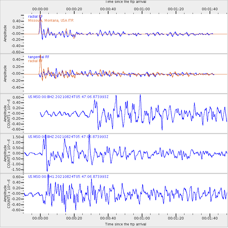
Signal To Noise
| Channel | StoN | STA | LTA |
| US:MSO:00:BHZ:20210824T05:47:06.873993Z | 13.405905 | 8.574805E-7 | 6.3962894E-8 |
| US:MSO:00:BH1:20210824T05:47:06.873993Z | 4.306152 | 2.5058714E-7 | 5.819283E-8 |
| US:MSO:00:BH2:20210824T05:47:06.873993Z | 5.342265 | 3.1047088E-7 | 5.8115962E-8 |
| Arrivals |
| Ps | 4.7 SECOND |
| PpPs | 15 SECOND |
| PsPs/PpSs | 20 SECOND |


