You are here: Home > Network List > US - United States National Seismic Network Stations List
> Station WRAK Wrangell Island, Southeastern Alaska, Alaska, USA > Earthquake Result Viewer
WRAK Wrangell Island, Southeastern Alaska, Alaska, USA - Earthquake Result Viewer
| Earthquake location: |
Kuril Islands |
| Earthquake latitude/longitude: |
48.8/155.0 |
| Earthquake time(UTC): |
2021/08/24 (236) 05:37:51 GMT |
| Earthquake Depth: |
31 km |
| Earthquake Magnitude: |
6.0 mww |
| Earthquake Catalog/Contributor: |
NEIC PDE/us |
|
| Network: |
US United States National Seismic Network |
| Station: |
WRAK Wrangell Island, Southeastern Alaska, Alaska, USA |
| Lat/Lon: |
56.42 N/132.35 W |
| Elevation: |
81 m |
|
| Distance: |
42.9 deg |
| Az: |
51.269 deg |
| Baz: |
291.888 deg |
| Ray Param: |
0.07286729 |
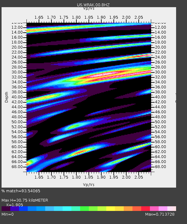
| Estimated Moho Depth: |
30.75 km |
| Estimated Crust Vp/Vs: |
1.90 |
| Assumed Crust Vp: |
6.597 km/s |
| Estimated Crust Vs: |
3.463 km/s |
| Estimated Crust Poisson's Ratio: |
0.31 |
|
| Radial Match: |
93.54065 % |
| Radial Bump: |
400 |
| Transverse Match: |
78.00898 % |
| Transverse Bump: |
400 |
| SOD ConfigId: |
25131211 |
| Insert Time: |
2021-09-07 06:10:56.624 +0000 |
| GWidth: |
2.5 |
| Max Bumps: |
400 |
| Tol: |
0.001 |
|
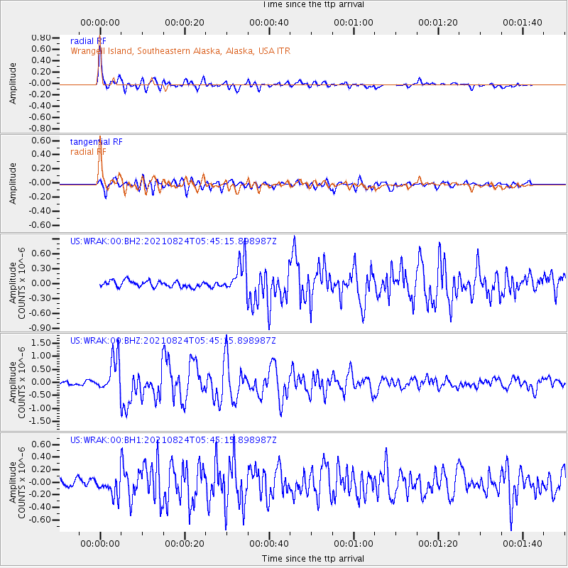
Signal To Noise
| Channel | StoN | STA | LTA |
| US:WRAK:00:BHZ:20210824T05:45:15.898987Z | 11.631948 | 7.039193E-7 | 6.051602E-8 |
| US:WRAK:00:BH1:20210824T05:45:15.898987Z | 2.9041142 | 1.55154E-7 | 5.3425584E-8 |
| US:WRAK:00:BH2:20210824T05:45:15.898987Z | 5.5639887 | 3.4259372E-7 | 6.15734E-8 |
| Arrivals |
| Ps | 4.5 SECOND |
| PpPs | 13 SECOND |
| PsPs/PpSs | 17 SECOND |


