You are here: Home > Network List > UW - Pacific Northwest Regional Seismic Network Stations List
> Station LNO Lincton Mt., Oregon previous ISC code: LNOR > Earthquake Result Viewer
LNO Lincton Mt., Oregon previous ISC code: LNOR - Earthquake Result Viewer
| Earthquake location: |
Kuril Islands |
| Earthquake latitude/longitude: |
48.8/155.0 |
| Earthquake time(UTC): |
2021/08/24 (236) 05:37:51 GMT |
| Earthquake Depth: |
31 km |
| Earthquake Magnitude: |
6.0 mww |
| Earthquake Catalog/Contributor: |
NEIC PDE/us |
|
| Network: |
UW Pacific Northwest Regional Seismic Network |
| Station: |
LNO Lincton Mt., Oregon previous ISC code: LNOR |
| Lat/Lon: |
45.87 N/118.29 W |
| Elevation: |
771 m |
|
| Distance: |
55.7 deg |
| Az: |
57.567 deg |
| Baz: |
307.013 deg |
| Ray Param: |
0.064555146 |
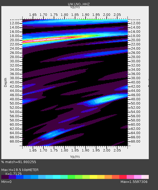
| Estimated Moho Depth: |
19.5 km |
| Estimated Crust Vp/Vs: |
1.71 |
| Assumed Crust Vp: |
6.571 km/s |
| Estimated Crust Vs: |
3.837 km/s |
| Estimated Crust Poisson's Ratio: |
0.24 |
|
| Radial Match: |
91.980255 % |
| Radial Bump: |
354 |
| Transverse Match: |
67.07337 % |
| Transverse Bump: |
400 |
| SOD ConfigId: |
25131211 |
| Insert Time: |
2021-09-07 06:12:52.620 +0000 |
| GWidth: |
2.5 |
| Max Bumps: |
400 |
| Tol: |
0.001 |
|

Signal To Noise
| Channel | StoN | STA | LTA |
| UW:LNO: :HHZ:20210824T05:46:54.129975Z | 7.1715226 | 6.618803E-7 | 9.229285E-8 |
| UW:LNO: :HHN:20210824T05:46:54.129975Z | 3.134872 | 1.7476465E-7 | 5.5748583E-8 |
| UW:LNO: :HHE:20210824T05:46:54.129975Z | 3.751571 | 2.2603041E-7 | 6.024953E-8 |
| Arrivals |
| Ps | 2.2 SECOND |
| PpPs | 7.6 SECOND |
| PsPs/PpSs | 9.8 SECOND |


