You are here: Home > Network List > WY - Yellowstone Wyoming Seismic Network Stations List
> Station YMP Mirror Lake Plateau, YNP, WY, USA > Earthquake Result Viewer
YMP Mirror Lake Plateau, YNP, WY, USA - Earthquake Result Viewer
| Earthquake location: |
Kuril Islands |
| Earthquake latitude/longitude: |
48.8/155.0 |
| Earthquake time(UTC): |
2021/08/24 (236) 05:37:51 GMT |
| Earthquake Depth: |
31 km |
| Earthquake Magnitude: |
6.0 mww |
| Earthquake Catalog/Contributor: |
NEIC PDE/us |
|
| Network: |
WY Yellowstone Wyoming Seismic Network |
| Station: |
YMP Mirror Lake Plateau, YNP, WY, USA |
| Lat/Lon: |
44.74 N/110.16 W |
| Elevation: |
2774 m |
|
| Distance: |
60.9 deg |
| Az: |
54.352 deg |
| Baz: |
311.088 deg |
| Ray Param: |
0.06118321 |
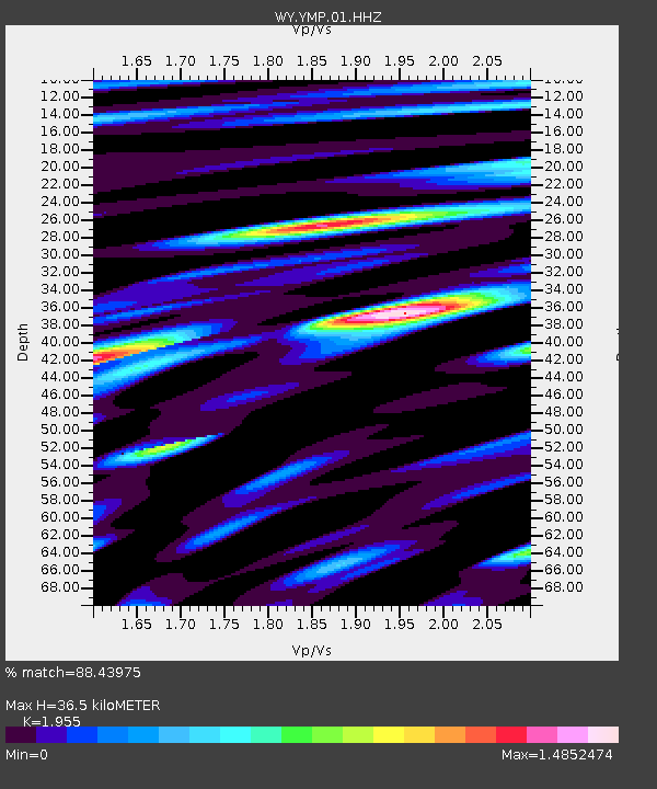
| Estimated Moho Depth: |
36.5 km |
| Estimated Crust Vp/Vs: |
1.96 |
| Assumed Crust Vp: |
6.35 km/s |
| Estimated Crust Vs: |
3.248 km/s |
| Estimated Crust Poisson's Ratio: |
0.32 |
|
| Radial Match: |
88.43975 % |
| Radial Bump: |
400 |
| Transverse Match: |
89.88686 % |
| Transverse Bump: |
400 |
| SOD ConfigId: |
25131211 |
| Insert Time: |
2021-09-07 06:14:55.055 +0000 |
| GWidth: |
2.5 |
| Max Bumps: |
400 |
| Tol: |
0.001 |
|

Signal To Noise
| Channel | StoN | STA | LTA |
| WY:YMP:01:HHZ:20210824T05:47:30.128021Z | 15.590729 | 2.8893654E-8 | 1.8532587E-9 |
| WY:YMP:01:HHN:20210824T05:47:30.128021Z | 5.447093 | 1.3378964E-8 | 2.456166E-9 |
| WY:YMP:01:HHE:20210824T05:47:30.128021Z | 3.9004245 | 9.058364E-9 | 2.3224047E-9 |
| Arrivals |
| Ps | 5.7 SECOND |
| PpPs | 16 SECOND |
| PsPs/PpSs | 22 SECOND |


