You are here: Home > Network List > CN - Canadian National Seismograph Network Stations List
> Station INK INUVIK, NT > Earthquake Result Viewer
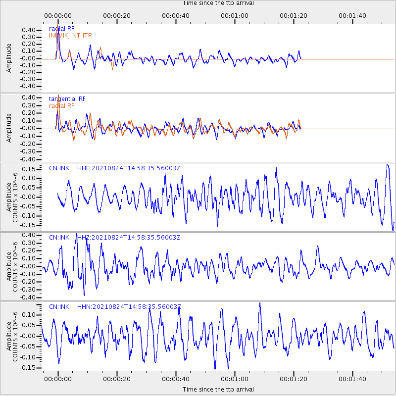
INK INUVIK, NT - Earthquake Result Viewer
*The percent match for this event was below the threshold and hence no stack was calculated.
| Earthquake location: |
South Of Mariana Islands |
| Earthquake latitude/longitude: |
12.7/145.1 |
| Earthquake time(UTC): |
2021/08/24 (236) 14:47:25 GMT |
| Earthquake Depth: |
10 km |
| Earthquake Magnitude: |
5.5 Mww |
| Earthquake Catalog/Contributor: |
NEIC PDE/us |
|
| Network: |
CN Canadian National Seismograph Network |
| Station: |
INK INUVIK, NT |
| Lat/Lon: |
68.31 N/133.53 W |
| Elevation: |
44 m |
|
| Distance: |
75.1 deg |
| Az: |
22.36 deg |
| Baz: |
266.766 deg |
| Ray Param: |
$rayparam |
*The percent match for this event was below the threshold and hence was not used in the summary stack. |
|
| Radial Match: |
62.556484 % |
| Radial Bump: |
370 |
| Transverse Match: |
59.541275 % |
| Transverse Bump: |
400 |
| SOD ConfigId: |
25131211 |
| Insert Time: |
2021-09-07 14:54:22.492 +0000 |
| GWidth: |
2.5 |
| Max Bumps: |
400 |
| Tol: |
0.001 |
|
Signal To Noise
| Channel | StoN | STA | LTA |
| CN:INK: :HHZ:20210824T14:58:35.56003Z | 3.432443 | 1.718816E-7 | 5.0075588E-8 |
| CN:INK: :HHN:20210824T14:58:35.56003Z | 1.7103761 | 5.805948E-8 | 3.3945447E-8 |
| CN:INK: :HHE:20210824T14:58:35.56003Z | 1.11139 | 4.6104727E-8 | 4.148384E-8 |
| Arrivals |
| Ps | |
| PpPs | |
| PsPs/PpSs | |


