You are here: Home > Network List > IU - Global Seismograph Network (GSN - IRIS/USGS) Stations List
> Station XMAS Kiritimati Island, Republic of Kiribati > Earthquake Result Viewer
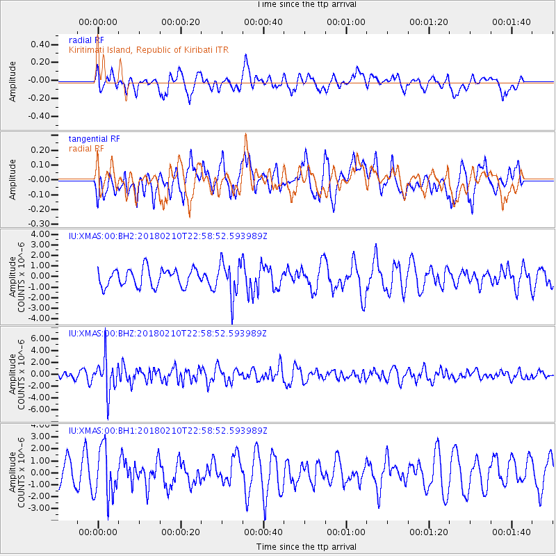
XMAS Kiritimati Island, Republic of Kiribati - Earthquake Result Viewer
*The percent match for this event was below the threshold and hence no stack was calculated.
| Earthquake location: |
New Ireland Region, P.N.G. |
| Earthquake latitude/longitude: |
-3.8/151.9 |
| Earthquake time(UTC): |
2018/02/10 (041) 22:50:48 GMT |
| Earthquake Depth: |
268 km |
| Earthquake Magnitude: |
5.8 Mww |
| Earthquake Catalog/Contributor: |
NEIC PDE/us |
|
| Network: |
IU Global Seismograph Network (GSN - IRIS/USGS) |
| Station: |
XMAS Kiritimati Island, Republic of Kiribati |
| Lat/Lon: |
2.04 N/157.45 W |
| Elevation: |
20 m |
|
| Distance: |
50.9 deg |
| Az: |
84.298 deg |
| Baz: |
263.47 deg |
| Ray Param: |
$rayparam |
*The percent match for this event was below the threshold and hence was not used in the summary stack. |
|
| Radial Match: |
49.350914 % |
| Radial Bump: |
400 |
| Transverse Match: |
54.981388 % |
| Transverse Bump: |
400 |
| SOD ConfigId: |
2546091 |
| Insert Time: |
2018-02-24 22:52:25.447 +0000 |
| GWidth: |
2.5 |
| Max Bumps: |
400 |
| Tol: |
0.001 |
|
Signal To Noise
| Channel | StoN | STA | LTA |
| IU:XMAS:00:BHZ:20180210T22:58:52.593989Z | 3.291908 | 2.929419E-6 | 8.898848E-7 |
| IU:XMAS:00:BH1:20180210T22:58:52.593989Z | 2.4923108 | 2.0527284E-6 | 8.2362453E-7 |
| IU:XMAS:00:BH2:20180210T22:58:52.593989Z | 2.0479643 | 1.6857042E-6 | 8.231121E-7 |
| Arrivals |
| Ps | |
| PpPs | |
| PsPs/PpSs | |


