You are here: Home > Network List > US - United States National Seismic Network Stations List
> Station EGMT Eagleton, Montana, USA > Earthquake Result Viewer
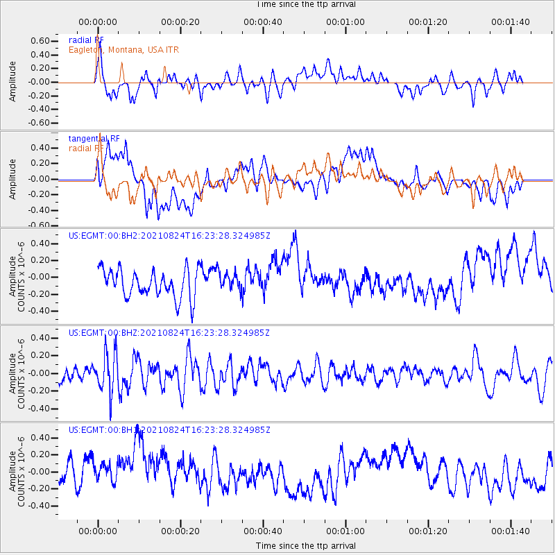
EGMT Eagleton, Montana, USA - Earthquake Result Viewer
*The percent match for this event was below the threshold and hence no stack was calculated.
| Earthquake location: |
Near Coast Of Guatemala |
| Earthquake latitude/longitude: |
13.4/-91.7 |
| Earthquake time(UTC): |
2021/08/24 (236) 16:16:44 GMT |
| Earthquake Depth: |
10 km |
| Earthquake Magnitude: |
5.6 Mww |
| Earthquake Catalog/Contributor: |
NEIC PDE/us |
|
| Network: |
US United States National Seismic Network |
| Station: |
EGMT Eagleton, Montana, USA |
| Lat/Lon: |
48.02 N/109.75 W |
| Elevation: |
1055 m |
|
| Distance: |
37.6 deg |
| Az: |
340.096 deg |
| Baz: |
150.428 deg |
| Ray Param: |
$rayparam |
*The percent match for this event was below the threshold and hence was not used in the summary stack. |
|
| Radial Match: |
47.08041 % |
| Radial Bump: |
400 |
| Transverse Match: |
28.808308 % |
| Transverse Bump: |
400 |
| SOD ConfigId: |
25131211 |
| Insert Time: |
2021-09-07 16:31:05.253 +0000 |
| GWidth: |
2.5 |
| Max Bumps: |
400 |
| Tol: |
0.001 |
|
Signal To Noise
| Channel | StoN | STA | LTA |
| US:EGMT:00:BHZ:20210824T16:23:28.324985Z | 3.006759 | 2.2839663E-7 | 7.5961076E-8 |
| US:EGMT:00:BH1:20210824T16:23:28.324985Z | 1.1295248 | 1.6397362E-7 | 1.4517045E-7 |
| US:EGMT:00:BH2:20210824T16:23:28.324985Z | 0.62182647 | 1.0184632E-7 | 1.6378576E-7 |
| Arrivals |
| Ps | |
| PpPs | |
| PsPs/PpSs | |


