You are here: Home > Network List > AV - Alaska Volcano Observatory Stations List
> Station PLBL Mt. Peulik Volcano, Alaska > Earthquake Result Viewer
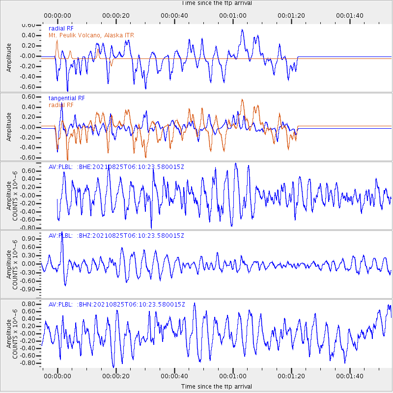
PLBL Mt. Peulik Volcano, Alaska - Earthquake Result Viewer
*The percent match for this event was below the threshold and hence no stack was calculated.
| Earthquake location: |
Kermadec Islands, New Zealand |
| Earthquake latitude/longitude: |
-29.7/-177.6 |
| Earthquake time(UTC): |
2021/08/25 (237) 05:58:03 GMT |
| Earthquake Depth: |
30 km |
| Earthquake Magnitude: |
5.7 mb |
| Earthquake Catalog/Contributor: |
NEIC PDE/us |
|
| Network: |
AV Alaska Volcano Observatory |
| Station: |
PLBL Mt. Peulik Volcano, Alaska |
| Lat/Lon: |
57.70 N/156.82 W |
| Elevation: |
461 m |
|
| Distance: |
88.8 deg |
| Az: |
10.966 deg |
| Baz: |
197.95 deg |
| Ray Param: |
$rayparam |
*The percent match for this event was below the threshold and hence was not used in the summary stack. |
|
| Radial Match: |
42.675205 % |
| Radial Bump: |
400 |
| Transverse Match: |
56.077755 % |
| Transverse Bump: |
400 |
| SOD ConfigId: |
25131211 |
| Insert Time: |
2021-09-08 06:02:07.322 +0000 |
| GWidth: |
2.5 |
| Max Bumps: |
400 |
| Tol: |
0.001 |
|
Signal To Noise
| Channel | StoN | STA | LTA |
| AV:PLBL: :BHZ:20210825T06:10:23.580015Z | 3.0718155 | 4.3253945E-7 | 1.4080905E-7 |
| AV:PLBL: :BHN:20210825T06:10:23.580015Z | 0.8105766 | 2.9529576E-7 | 3.6430333E-7 |
| AV:PLBL: :BHE:20210825T06:10:23.580015Z | 1.0021166 | 3.0534463E-7 | 3.046997E-7 |
| Arrivals |
| Ps | |
| PpPs | |
| PsPs/PpSs | |


