You are here: Home > Network List > CI - Caltech Regional Seismic Network Stations List
> Station MPM Manuel Prospect Mine, California, USA > Earthquake Result Viewer
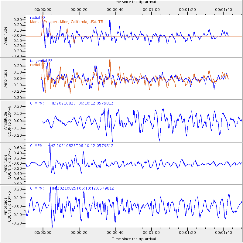
MPM Manuel Prospect Mine, California, USA - Earthquake Result Viewer
*The percent match for this event was below the threshold and hence no stack was calculated.
| Earthquake location: |
Kermadec Islands, New Zealand |
| Earthquake latitude/longitude: |
-29.7/-177.6 |
| Earthquake time(UTC): |
2021/08/25 (237) 05:58:03 GMT |
| Earthquake Depth: |
30 km |
| Earthquake Magnitude: |
5.7 mb |
| Earthquake Catalog/Contributor: |
NEIC PDE/us |
|
| Network: |
CI Caltech Regional Seismic Network |
| Station: |
MPM Manuel Prospect Mine, California, USA |
| Lat/Lon: |
36.06 N/117.49 W |
| Elevation: |
185 m |
|
| Distance: |
86.4 deg |
| Az: |
44.721 deg |
| Baz: |
229.062 deg |
| Ray Param: |
$rayparam |
*The percent match for this event was below the threshold and hence was not used in the summary stack. |
|
| Radial Match: |
72.63775 % |
| Radial Bump: |
400 |
| Transverse Match: |
64.82816 % |
| Transverse Bump: |
338 |
| SOD ConfigId: |
25131211 |
| Insert Time: |
2021-09-08 06:05:55.862 +0000 |
| GWidth: |
2.5 |
| Max Bumps: |
400 |
| Tol: |
0.001 |
|
Signal To Noise
| Channel | StoN | STA | LTA |
| CI:MPM: :HHZ:20210825T06:10:12.057981Z | 5.121519 | 2.5461355E-7 | 4.9714462E-8 |
| CI:MPM: :HHN:20210825T06:10:12.057981Z | 1.7776301 | 7.6391494E-8 | 4.2973788E-8 |
| CI:MPM: :HHE:20210825T06:10:12.057981Z | 2.2198372 | 8.8459046E-8 | 3.984934E-8 |
| Arrivals |
| Ps | |
| PpPs | |
| PsPs/PpSs | |


