You are here: Home > Network List > IM - International Miscellaneous Stations Stations List
> Station TKL Tuckaleechee Caverns, TN, USA > Earthquake Result Viewer
TKL Tuckaleechee Caverns, TN, USA - Earthquake Result Viewer
| Earthquake location: |
Northern Mid-Atlantic Ridge |
| Earthquake latitude/longitude: |
23.9/-46.1 |
| Earthquake time(UTC): |
2009/06/06 (157) 20:33:28 GMT |
| Earthquake Depth: |
14 km |
| Earthquake Magnitude: |
6.0 MB, 5.7 MS, 6.0 MW, 6.0 MW |
| Earthquake Catalog/Contributor: |
WHDF/NEIC |
|
| Network: |
IM International Miscellaneous Stations |
| Station: |
TKL Tuckaleechee Caverns, TN, USA |
| Lat/Lon: |
35.66 N/83.77 W |
| Elevation: |
351 m |
|
| Distance: |
34.6 deg |
| Az: |
298.659 deg |
| Baz: |
99.434 deg |
| Ray Param: |
0.07767395 |
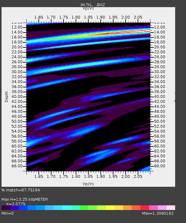
| Estimated Moho Depth: |
13.25 km |
| Estimated Crust Vp/Vs: |
2.08 |
| Assumed Crust Vp: |
6.35 km/s |
| Estimated Crust Vs: |
3.057 km/s |
| Estimated Crust Poisson's Ratio: |
0.35 |
|
| Radial Match: |
87.75194 % |
| Radial Bump: |
400 |
| Transverse Match: |
57.357304 % |
| Transverse Bump: |
400 |
| SOD ConfigId: |
2648 |
| Insert Time: |
2010-03-09 12:01:49.588 +0000 |
| GWidth: |
2.5 |
| Max Bumps: |
400 |
| Tol: |
0.001 |
|

Signal To Noise
| Channel | StoN | STA | LTA |
| IM:TKL: :BHZ:20090606T20:39:46.050001Z | 5.0700107 | 7.857007E-8 | 1.5497024E-8 |
| IM:TKL: :BHN:20090606T20:39:46.050001Z | 2.4320395 | 3.438665E-8 | 1.4139018E-8 |
| IM:TKL: :BHE:20090606T20:39:46.050001Z | 5.008743 | 5.604738E-8 | 1.1189909E-8 |
| Arrivals |
| Ps | 2.4 SECOND |
| PpPs | 6.0 SECOND |
| PsPs/PpSs | 8.4 SECOND |


