You are here: Home > Network List > CN - Canadian National Seismograph Network Stations List
> Station INK INUVIK, NT > Earthquake Result Viewer
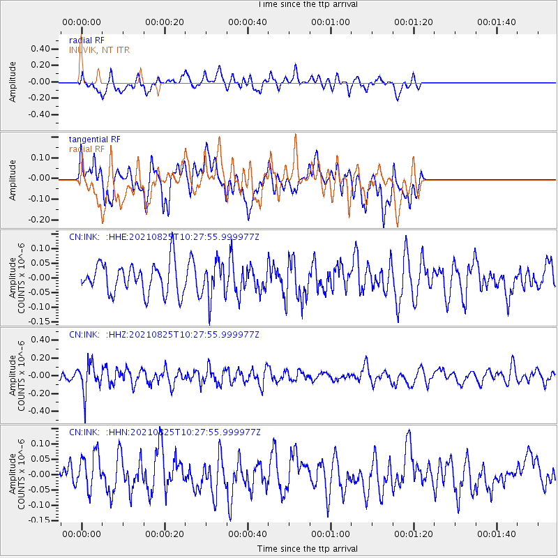
INK INUVIK, NT - Earthquake Result Viewer
*The percent match for this event was below the threshold and hence no stack was calculated.
| Earthquake location: |
Southeast Of Honshu, Japan |
| Earthquake latitude/longitude: |
29.7/141.4 |
| Earthquake time(UTC): |
2021/08/25 (237) 10:18:16 GMT |
| Earthquake Depth: |
35 km |
| Earthquake Magnitude: |
5.3 Mww |
| Earthquake Catalog/Contributor: |
NEIC PDE/us |
|
| Network: |
CN Canadian National Seismograph Network |
| Station: |
INK INUVIK, NT |
| Lat/Lon: |
68.31 N/133.53 W |
| Elevation: |
44 m |
|
| Distance: |
61.0 deg |
| Az: |
25.061 deg |
| Baz: |
277.427 deg |
| Ray Param: |
$rayparam |
*The percent match for this event was below the threshold and hence was not used in the summary stack. |
|
| Radial Match: |
63.655445 % |
| Radial Bump: |
400 |
| Transverse Match: |
51.779858 % |
| Transverse Bump: |
400 |
| SOD ConfigId: |
25131211 |
| Insert Time: |
2021-09-08 10:28:48.458 +0000 |
| GWidth: |
2.5 |
| Max Bumps: |
400 |
| Tol: |
0.001 |
|
Signal To Noise
| Channel | StoN | STA | LTA |
| CN:INK: :HHZ:20210825T10:27:55.999977Z | 2.1416256 | 1.5806064E-7 | 7.380405E-8 |
| CN:INK: :HHN:20210825T10:27:55.999977Z | 1.3031229 | 6.156496E-8 | 4.7244175E-8 |
| CN:INK: :HHE:20210825T10:27:55.999977Z | 1.1711197 | 6.0747965E-8 | 5.187169E-8 |
| Arrivals |
| Ps | |
| PpPs | |
| PsPs/PpSs | |


