You are here: Home > Network List > US - United States National Seismic Network Stations List
> Station WUAZ Wupatki, Arizona, USA > Earthquake Result Viewer
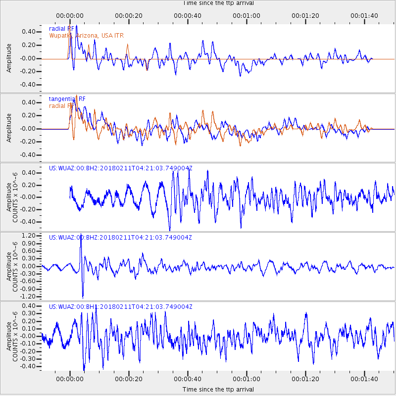
WUAZ Wupatki, Arizona, USA - Earthquake Result Viewer
*The percent match for this event was below the threshold and hence no stack was calculated.
| Earthquake location: |
Near Coast Of Peru |
| Earthquake latitude/longitude: |
-16.7/-74.2 |
| Earthquake time(UTC): |
2018/02/11 (042) 04:11:09 GMT |
| Earthquake Depth: |
10 km |
| Earthquake Magnitude: |
5.4 Mww |
| Earthquake Catalog/Contributor: |
NEIC PDE/us |
|
| Network: |
US United States National Seismic Network |
| Station: |
WUAZ Wupatki, Arizona, USA |
| Lat/Lon: |
35.52 N/111.37 W |
| Elevation: |
1592 m |
|
| Distance: |
62.8 deg |
| Az: |
326.297 deg |
| Baz: |
139.315 deg |
| Ray Param: |
$rayparam |
*The percent match for this event was below the threshold and hence was not used in the summary stack. |
|
| Radial Match: |
73.057884 % |
| Radial Bump: |
400 |
| Transverse Match: |
51.00132 % |
| Transverse Bump: |
400 |
| SOD ConfigId: |
2546091 |
| Insert Time: |
2018-02-25 04:16:28.473 +0000 |
| GWidth: |
2.5 |
| Max Bumps: |
400 |
| Tol: |
0.001 |
|
Signal To Noise
| Channel | StoN | STA | LTA |
| US:WUAZ:00:BHZ:20180211T04:21:03.749004Z | 4.3553224 | 4.6736594E-7 | 1.0730915E-7 |
| US:WUAZ:00:BH1:20180211T04:21:03.749004Z | 2.086828 | 1.7928625E-7 | 8.5913285E-8 |
| US:WUAZ:00:BH2:20180211T04:21:03.749004Z | 2.2815545 | 2.2917507E-7 | 1.004469E-7 |
| Arrivals |
| Ps | |
| PpPs | |
| PsPs/PpSs | |


