You are here: Home > Network List > WY - Yellowstone Wyoming Seismic Network Stations List
> Station YHH Holmes Hill, YNP, WY, USA > Earthquake Result Viewer
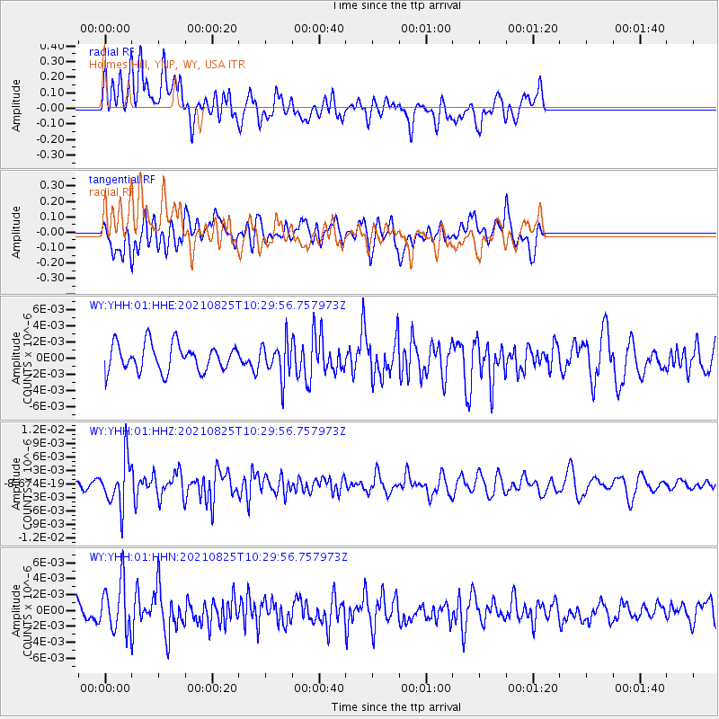
YHH Holmes Hill, YNP, WY, USA - Earthquake Result Viewer
*The percent match for this event was below the threshold and hence no stack was calculated.
| Earthquake location: |
Southeast Of Honshu, Japan |
| Earthquake latitude/longitude: |
29.7/141.4 |
| Earthquake time(UTC): |
2021/08/25 (237) 10:18:16 GMT |
| Earthquake Depth: |
35 km |
| Earthquake Magnitude: |
5.3 Mww |
| Earthquake Catalog/Contributor: |
NEIC PDE/us |
|
| Network: |
WY Yellowstone Wyoming Seismic Network |
| Station: |
YHH Holmes Hill, YNP, WY, USA |
| Lat/Lon: |
44.79 N/110.85 W |
| Elevation: |
2717 m |
|
| Distance: |
81.0 deg |
| Az: |
43.386 deg |
| Baz: |
302.901 deg |
| Ray Param: |
$rayparam |
*The percent match for this event was below the threshold and hence was not used in the summary stack. |
|
| Radial Match: |
63.040176 % |
| Radial Bump: |
400 |
| Transverse Match: |
47.301014 % |
| Transverse Bump: |
400 |
| SOD ConfigId: |
25131211 |
| Insert Time: |
2021-09-08 10:43:51.180 +0000 |
| GWidth: |
2.5 |
| Max Bumps: |
400 |
| Tol: |
0.001 |
|
Signal To Noise
| Channel | StoN | STA | LTA |
| WY:YHH:01:HHZ:20210825T10:29:56.757973Z | 2.954572 | 5.2823017E-9 | 1.7878399E-9 |
| WY:YHH:01:HHN:20210825T10:29:56.757973Z | 2.2234042 | 3.0910914E-9 | 1.3902516E-9 |
| WY:YHH:01:HHE:20210825T10:29:56.757973Z | 1.3139918 | 2.2104052E-9 | 1.6822063E-9 |
| Arrivals |
| Ps | |
| PpPs | |
| PsPs/PpSs | |


