You are here: Home > Network List > IU - Global Seismograph Network (GSN - IRIS/USGS) Stations List
> Station CTAO Charters Towers, Australia > Earthquake Result Viewer
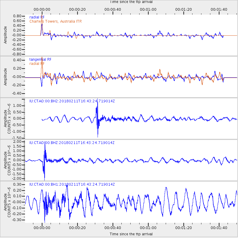
CTAO Charters Towers, Australia - Earthquake Result Viewer
*The percent match for this event was below the threshold and hence no stack was calculated.
| Earthquake location: |
Fiji Islands Region |
| Earthquake latitude/longitude: |
-20.9/-179.1 |
| Earthquake time(UTC): |
2018/02/11 (042) 16:38:14 GMT |
| Earthquake Depth: |
631 km |
| Earthquake Magnitude: |
5.5 Mww |
| Earthquake Catalog/Contributor: |
NEIC PDE/us |
|
| Network: |
IU Global Seismograph Network (GSN - IRIS/USGS) |
| Station: |
CTAO Charters Towers, Australia |
| Lat/Lon: |
20.09 S/146.25 E |
| Elevation: |
357 m |
|
| Distance: |
32.4 deg |
| Az: |
265.224 deg |
| Baz: |
97.606 deg |
| Ray Param: |
$rayparam |
*The percent match for this event was below the threshold and hence was not used in the summary stack. |
|
| Radial Match: |
48.131332 % |
| Radial Bump: |
314 |
| Transverse Match: |
45.721756 % |
| Transverse Bump: |
347 |
| SOD ConfigId: |
2546091 |
| Insert Time: |
2018-02-25 17:37:48.198 +0000 |
| GWidth: |
2.5 |
| Max Bumps: |
400 |
| Tol: |
0.001 |
|
Signal To Noise
| Channel | StoN | STA | LTA |
| IU:CTAO:00:BHZ:20180211T16:43:24.719014Z | 10.0624485 | 6.013348E-7 | 5.976029E-8 |
| IU:CTAO:00:BH1:20180211T16:43:24.719014Z | 1.6136814 | 1.3042987E-7 | 8.082751E-8 |
| IU:CTAO:00:BH2:20180211T16:43:24.719014Z | 3.2523124 | 4.2064605E-7 | 1.2933752E-7 |
| Arrivals |
| Ps | |
| PpPs | |
| PsPs/PpSs | |


