You are here: Home > Network List > GO - National Seismic Network of Georgia Stations List
> Station TBLG Delisi, Georgia > Earthquake Result Viewer
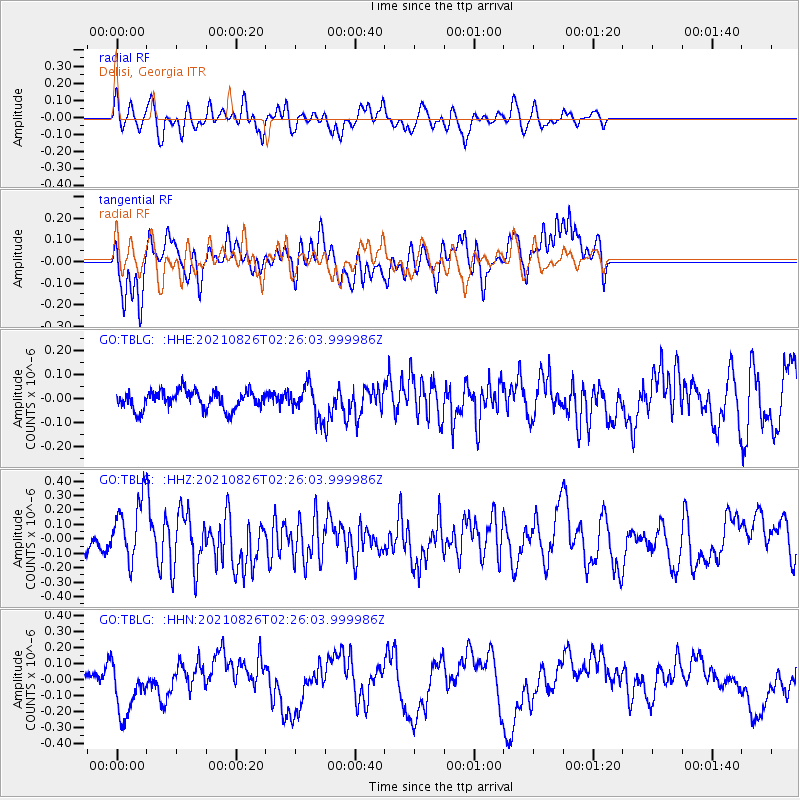
TBLG Delisi, Georgia - Earthquake Result Viewer
*The percent match for this event was below the threshold and hence no stack was calculated.
| Earthquake location: |
Minahassa Peninsula, Sulawesi |
| Earthquake latitude/longitude: |
-0.8/121.6 |
| Earthquake time(UTC): |
2021/08/26 (238) 02:14:21 GMT |
| Earthquake Depth: |
10 km |
| Earthquake Magnitude: |
5.5 mww |
| Earthquake Catalog/Contributor: |
NEIC PDE/us |
|
| Network: |
GO National Seismic Network of Georgia |
| Station: |
TBLG Delisi, Georgia |
| Lat/Lon: |
41.73 N/44.74 E |
| Elevation: |
510 m |
|
| Distance: |
80.8 deg |
| Az: |
312.398 deg |
| Baz: |
99.419 deg |
| Ray Param: |
$rayparam |
*The percent match for this event was below the threshold and hence was not used in the summary stack. |
|
| Radial Match: |
62.255733 % |
| Radial Bump: |
400 |
| Transverse Match: |
40.02956 % |
| Transverse Bump: |
400 |
| SOD ConfigId: |
25131211 |
| Insert Time: |
2021-09-09 02:18:27.787 +0000 |
| GWidth: |
2.5 |
| Max Bumps: |
400 |
| Tol: |
0.001 |
|
Signal To Noise
| Channel | StoN | STA | LTA |
| GO:TBLG: :HHZ:20210826T02:26:03.999986Z | 2.2828126 | 2.1589088E-7 | 9.4572314E-8 |
| GO:TBLG: :HHN:20210826T02:26:03.999986Z | 2.2155933 | 1.7055088E-7 | 7.6977514E-8 |
| GO:TBLG: :HHE:20210826T02:26:03.999986Z | 1.6375431 | 6.25768E-8 | 3.8213834E-8 |
| Arrivals |
| Ps | |
| PpPs | |
| PsPs/PpSs | |


