You are here: Home > Network List > WI - West Indies IPGP Network Stations List
> Station BIM Morne Bigot, Anses d'Arlets, Martinique > Earthquake Result Viewer
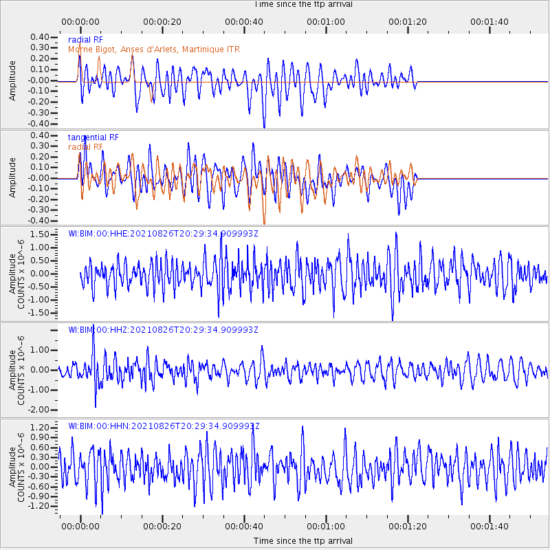
BIM Morne Bigot, Anses d'Arlets, Martinique - Earthquake Result Viewer
*The percent match for this event was below the threshold and hence no stack was calculated.
| Earthquake location: |
South Sandwich Islands Region |
| Earthquake latitude/longitude: |
-57.1/-25.5 |
| Earthquake time(UTC): |
2021/08/26 (238) 20:18:14 GMT |
| Earthquake Depth: |
31 km |
| Earthquake Magnitude: |
5.3 Mww |
| Earthquake Catalog/Contributor: |
NEIC PDE/us |
|
| Network: |
WI West Indies IPGP Network |
| Station: |
BIM Morne Bigot, Anses d'Arlets, Martinique |
| Lat/Lon: |
14.52 N/61.07 W |
| Elevation: |
391 m |
|
| Distance: |
77.2 deg |
| Az: |
324.686 deg |
| Baz: |
161.0 deg |
| Ray Param: |
$rayparam |
*The percent match for this event was below the threshold and hence was not used in the summary stack. |
|
| Radial Match: |
52.62423 % |
| Radial Bump: |
400 |
| Transverse Match: |
53.552734 % |
| Transverse Bump: |
400 |
| SOD ConfigId: |
25131211 |
| Insert Time: |
2021-09-09 20:22:48.489 +0000 |
| GWidth: |
2.5 |
| Max Bumps: |
400 |
| Tol: |
0.001 |
|
Signal To Noise
| Channel | StoN | STA | LTA |
| WI:BIM:00:HHZ:20210826T20:29:34.909993Z | 2.6895022 | 7.378393E-7 | 2.7434047E-7 |
| WI:BIM:00:HHN:20210826T20:29:34.909993Z | 1.1440865 | 5.130738E-7 | 4.484572E-7 |
| WI:BIM:00:HHE:20210826T20:29:34.909993Z | 1.5951588 | 6.821925E-7 | 4.2766428E-7 |
| Arrivals |
| Ps | |
| PpPs | |
| PsPs/PpSs | |


