You are here: Home > Network List > AK - Alaska Regional Network Stations List
> Station M20K Styx River, AK, USA > Earthquake Result Viewer
M20K Styx River, AK, USA - Earthquake Result Viewer
| Earthquake location: |
Mindanao, Philippines |
| Earthquake latitude/longitude: |
5.7/125.2 |
| Earthquake time(UTC): |
2021/08/27 (239) 10:22:26 GMT |
| Earthquake Depth: |
39 km |
| Earthquake Magnitude: |
5.6 Mww |
| Earthquake Catalog/Contributor: |
NEIC PDE/us |
|
| Network: |
AK Alaska Regional Network |
| Station: |
M20K Styx River, AK, USA |
| Lat/Lon: |
61.88 N/153.13 W |
| Elevation: |
1107 m |
|
| Distance: |
81.0 deg |
| Az: |
28.326 deg |
| Baz: |
265.311 deg |
| Ray Param: |
0.047809962 |
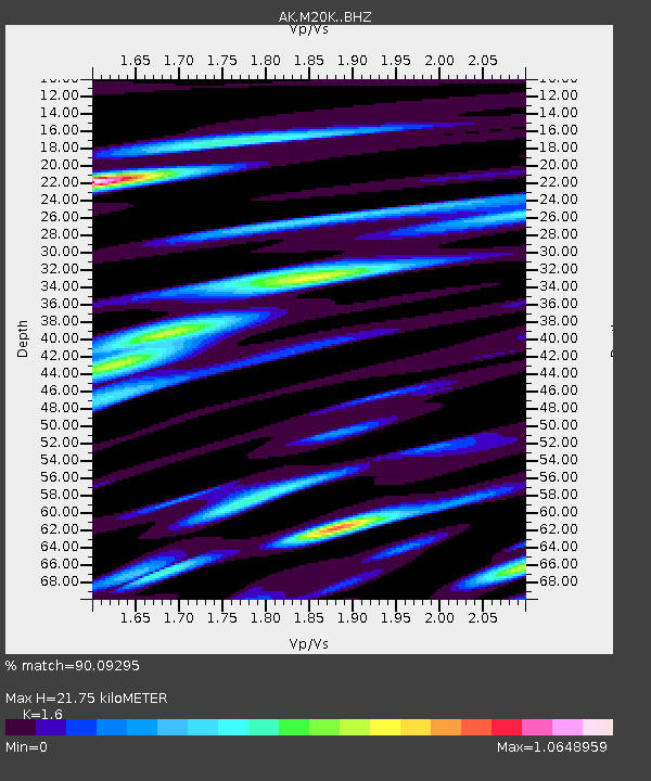
| Estimated Moho Depth: |
21.75 km |
| Estimated Crust Vp/Vs: |
1.60 |
| Assumed Crust Vp: |
6.566 km/s |
| Estimated Crust Vs: |
4.104 km/s |
| Estimated Crust Poisson's Ratio: |
0.18 |
|
| Radial Match: |
90.09295 % |
| Radial Bump: |
400 |
| Transverse Match: |
86.068756 % |
| Transverse Bump: |
400 |
| SOD ConfigId: |
25131211 |
| Insert Time: |
2021-09-10 10:25:26.655 +0000 |
| GWidth: |
2.5 |
| Max Bumps: |
400 |
| Tol: |
0.001 |
|

Signal To Noise
| Channel | StoN | STA | LTA |
| AK:M20K: :BHZ:20210827T10:34:06.200016Z | 32.776356 | 1.1319482E-6 | 3.4535514E-8 |
| AK:M20K: :BHN:20210827T10:34:06.200016Z | 4.0125017 | 2.4940059E-7 | 6.215588E-8 |
| AK:M20K: :BHE:20210827T10:34:06.200016Z | 7.808557 | 5.037464E-7 | 6.451209E-8 |
| Arrivals |
| Ps | 2.1 SECOND |
| PpPs | 8.3 SECOND |
| PsPs/PpSs | 10 SECOND |


