You are here: Home > Network List > AK - Alaska Regional Network Stations List
> Station PS10 TAPS Pump Station 10, AK, USA > Earthquake Result Viewer
PS10 TAPS Pump Station 10, AK, USA - Earthquake Result Viewer
| Earthquake location: |
Mindanao, Philippines |
| Earthquake latitude/longitude: |
5.7/125.2 |
| Earthquake time(UTC): |
2021/08/27 (239) 10:22:26 GMT |
| Earthquake Depth: |
39 km |
| Earthquake Magnitude: |
5.6 Mww |
| Earthquake Catalog/Contributor: |
NEIC PDE/us |
|
| Network: |
AK Alaska Regional Network |
| Station: |
PS10 TAPS Pump Station 10, AK, USA |
| Lat/Lon: |
63.42 N/145.77 W |
| Elevation: |
738 m |
|
| Distance: |
84.5 deg |
| Az: |
26.861 deg |
| Baz: |
271.66 deg |
| Ray Param: |
0.045399293 |
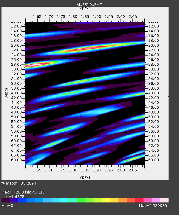
| Estimated Moho Depth: |
28.0 km |
| Estimated Crust Vp/Vs: |
1.64 |
| Assumed Crust Vp: |
6.566 km/s |
| Estimated Crust Vs: |
4.01 km/s |
| Estimated Crust Poisson's Ratio: |
0.20 |
|
| Radial Match: |
83.2894 % |
| Radial Bump: |
400 |
| Transverse Match: |
82.63745 % |
| Transverse Bump: |
400 |
| SOD ConfigId: |
25131211 |
| Insert Time: |
2021-09-10 10:26:06.702 +0000 |
| GWidth: |
2.5 |
| Max Bumps: |
400 |
| Tol: |
0.001 |
|

Signal To Noise
| Channel | StoN | STA | LTA |
| AK:PS10: :BHZ:20210827T10:34:23.968021Z | 10.703467 | 1.3354213E-6 | 1.247653E-7 |
| AK:PS10: :BHN:20210827T10:34:23.968021Z | 9.810788 | 8.724444E-7 | 8.8927045E-8 |
| AK:PS10: :BHE:20210827T10:34:23.968021Z | 13.061925 | 1.2059288E-6 | 9.232397E-8 |
| Arrivals |
| Ps | 2.8 SECOND |
| PpPs | 11 SECOND |
| PsPs/PpSs | 14 SECOND |


