You are here: Home > Network List > ND - New CaleDonia Broadband Seismic Network Stations List
> Station KOUNC Koumac, New Caledonia > Earthquake Result Viewer
KOUNC Koumac, New Caledonia - Earthquake Result Viewer
| Earthquake location: |
South Of Mariana Islands |
| Earthquake latitude/longitude: |
13.8/146.5 |
| Earthquake time(UTC): |
2018/02/11 (042) 23:14:18 GMT |
| Earthquake Depth: |
42 km |
| Earthquake Magnitude: |
6.2 Mi |
| Earthquake Catalog/Contributor: |
NEIC PDE/pt |
|
| Network: |
ND New CaleDonia Broadband Seismic Network |
| Station: |
KOUNC Koumac, New Caledonia |
| Lat/Lon: |
20.55 S/164.29 E |
| Elevation: |
88 m |
|
| Distance: |
38.4 deg |
| Az: |
152.575 deg |
| Baz: |
331.484 deg |
| Ray Param: |
0.07550064 |
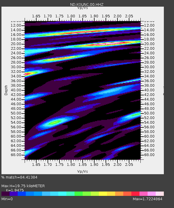
| Estimated Moho Depth: |
19.75 km |
| Estimated Crust Vp/Vs: |
1.95 |
| Assumed Crust Vp: |
5.14 km/s |
| Estimated Crust Vs: |
2.639 km/s |
| Estimated Crust Poisson's Ratio: |
0.32 |
|
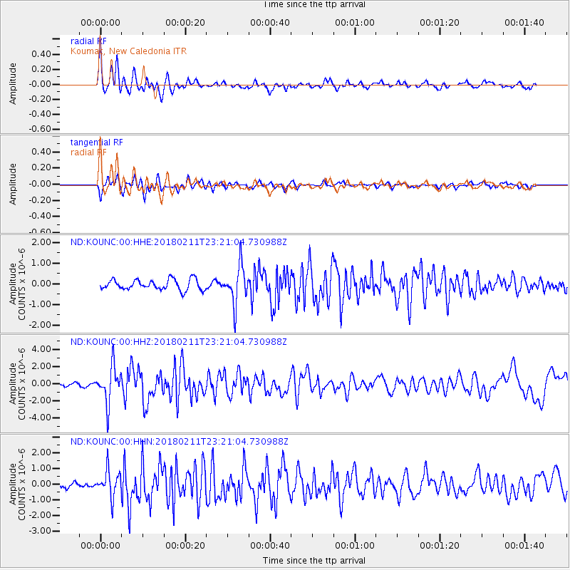
| Radial Match: |
84.41384 % |
| Radial Bump: |
400 |
| Transverse Match: |
74.65357 % |
| Transverse Bump: |
400 |
| SOD ConfigId: |
2546091 |
| Insert Time: |
2018-02-25 23:18:09.109 +0000 |
| GWidth: |
2.5 |
| Max Bumps: |
400 |
| Tol: |
0.001 |
|
Signal To Noise
| Channel | StoN | STA | LTA |
| ND:KOUNC:00:HHZ:20180211T23:21:04.730988Z | 7.702731 | 2.131414E-6 | 2.7670887E-7 |
| ND:KOUNC:00:HHN:20180211T23:21:04.730988Z | 5.1382666 | 8.605745E-7 | 1.6748344E-7 |
| ND:KOUNC:00:HHE:20180211T23:21:04.730988Z | 3.6549597 | 9.239263E-7 | 2.52787E-7 |
| Arrivals |
| Ps | 3.8 SECOND |
| PpPs | 11 SECOND |
| PsPs/PpSs | 15 SECOND |


