You are here: Home > Network List > AV - Alaska Volcano Observatory Stations List
> Station KAWH Katmai, Alaska > Earthquake Result Viewer
KAWH Katmai, Alaska - Earthquake Result Viewer
| Earthquake location: |
Mindanao, Philippines |
| Earthquake latitude/longitude: |
5.7/125.2 |
| Earthquake time(UTC): |
2021/08/27 (239) 10:22:26 GMT |
| Earthquake Depth: |
39 km |
| Earthquake Magnitude: |
5.6 Mww |
| Earthquake Catalog/Contributor: |
NEIC PDE/us |
|
| Network: |
AV Alaska Volcano Observatory |
| Station: |
KAWH Katmai, Alaska |
| Lat/Lon: |
58.38 N/154.80 W |
| Elevation: |
777 m |
|
| Distance: |
79.9 deg |
| Az: |
31.796 deg |
| Baz: |
264.44 deg |
| Ray Param: |
0.048594724 |
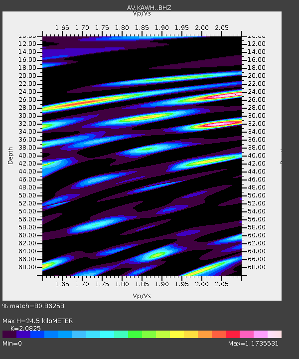
| Estimated Moho Depth: |
24.5 km |
| Estimated Crust Vp/Vs: |
2.08 |
| Assumed Crust Vp: |
6.438 km/s |
| Estimated Crust Vs: |
3.092 km/s |
| Estimated Crust Poisson's Ratio: |
0.35 |
|
| Radial Match: |
80.86258 % |
| Radial Bump: |
400 |
| Transverse Match: |
60.226376 % |
| Transverse Bump: |
400 |
| SOD ConfigId: |
25131211 |
| Insert Time: |
2021-09-10 10:28:45.829 +0000 |
| GWidth: |
2.5 |
| Max Bumps: |
400 |
| Tol: |
0.001 |
|

Signal To Noise
| Channel | StoN | STA | LTA |
| AV:KAWH: :BHZ:20210827T10:34:00.080021Z | 13.446421 | 4.894033E-7 | 3.6396553E-8 |
| AV:KAWH: :BHN:20210827T10:34:00.080021Z | 4.1064267 | 2.1197012E-7 | 5.161911E-8 |
| AV:KAWH: :BHE:20210827T10:34:00.080021Z | 6.5623546 | 2.701214E-7 | 4.116227E-8 |
| Arrivals |
| Ps | 4.2 SECOND |
| PpPs | 11 SECOND |
| PsPs/PpSs | 16 SECOND |


