You are here: Home > Network List > AV - Alaska Volcano Observatory Stations List
> Station MNAT Nateekin Bay, Makushin Volcano, Alaska > Earthquake Result Viewer
MNAT Nateekin Bay, Makushin Volcano, Alaska - Earthquake Result Viewer
| Earthquake location: |
Mindanao, Philippines |
| Earthquake latitude/longitude: |
5.7/125.2 |
| Earthquake time(UTC): |
2021/08/27 (239) 10:22:26 GMT |
| Earthquake Depth: |
39 km |
| Earthquake Magnitude: |
5.6 Mww |
| Earthquake Catalog/Contributor: |
NEIC PDE/us |
|
| Network: |
AV Alaska Volcano Observatory |
| Station: |
MNAT Nateekin Bay, Makushin Volcano, Alaska |
| Lat/Lon: |
53.88 N/166.69 W |
| Elevation: |
390 m |
|
| Distance: |
72.6 deg |
| Az: |
35.145 deg |
| Baz: |
255.373 deg |
| Ray Param: |
0.053526815 |
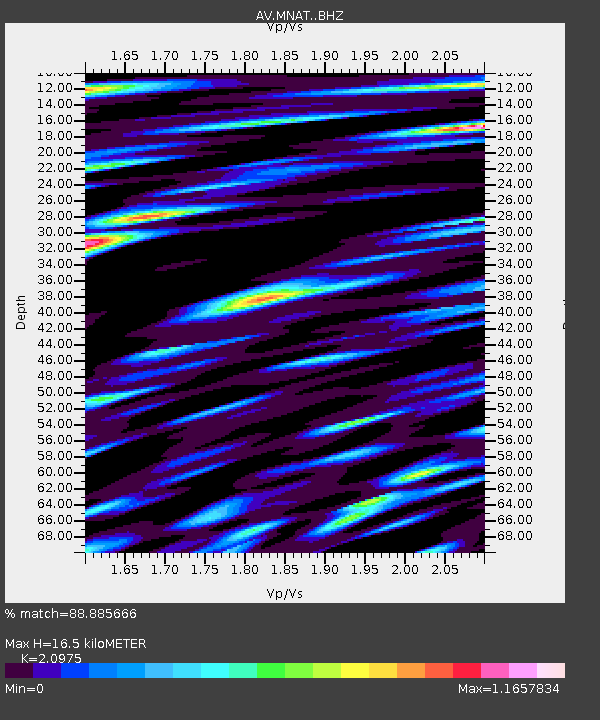
| Estimated Moho Depth: |
16.5 km |
| Estimated Crust Vp/Vs: |
2.10 |
| Assumed Crust Vp: |
3.943 km/s |
| Estimated Crust Vs: |
1.88 km/s |
| Estimated Crust Poisson's Ratio: |
0.35 |
|
| Radial Match: |
88.885666 % |
| Radial Bump: |
400 |
| Transverse Match: |
86.052925 % |
| Transverse Bump: |
400 |
| SOD ConfigId: |
25131211 |
| Insert Time: |
2021-09-10 10:29:16.483 +0000 |
| GWidth: |
2.5 |
| Max Bumps: |
400 |
| Tol: |
0.001 |
|

Signal To Noise
| Channel | StoN | STA | LTA |
| AV:MNAT: :BHZ:20210827T10:33:18.580021Z | 21.230854 | 1.29345E-6 | 6.092313E-8 |
| AV:MNAT: :BHN:20210827T10:33:18.580021Z | 8.444445 | 5.657155E-7 | 6.699263E-8 |
| AV:MNAT: :BHE:20210827T10:33:18.580021Z | 10.4740095 | 7.0729897E-7 | 6.752896E-8 |
| Arrivals |
| Ps | 4.6 SECOND |
| PpPs | 13 SECOND |
| PsPs/PpSs | 17 SECOND |


