You are here: Home > Network List > TA - USArray Transportable Network (new EarthScope stations) Stations List
> Station TOLK Toolik Lake Research Station, AK, USA > Earthquake Result Viewer
TOLK Toolik Lake Research Station, AK, USA - Earthquake Result Viewer
| Earthquake location: |
South Of Mariana Islands |
| Earthquake latitude/longitude: |
13.8/146.5 |
| Earthquake time(UTC): |
2018/02/11 (042) 23:14:18 GMT |
| Earthquake Depth: |
42 km |
| Earthquake Magnitude: |
6.2 Mi |
| Earthquake Catalog/Contributor: |
NEIC PDE/pt |
|
| Network: |
TA USArray Transportable Network (new EarthScope stations) |
| Station: |
TOLK Toolik Lake Research Station, AK, USA |
| Lat/Lon: |
68.64 N/149.57 W |
| Elevation: |
760 m |
|
| Distance: |
67.8 deg |
| Az: |
20.812 deg |
| Baz: |
250.408 deg |
| Ray Param: |
0.05663464 |
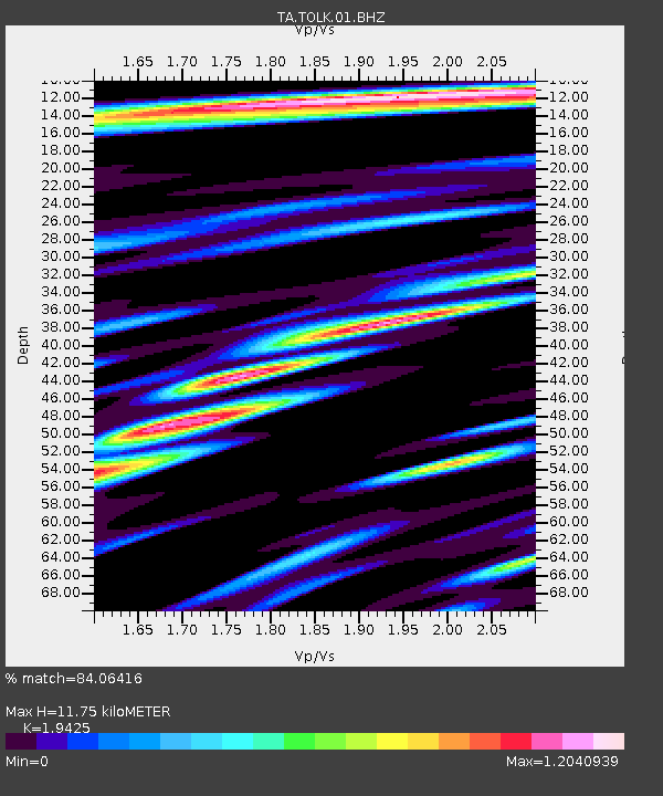
| Estimated Moho Depth: |
11.75 km |
| Estimated Crust Vp/Vs: |
1.94 |
| Assumed Crust Vp: |
6.316 km/s |
| Estimated Crust Vs: |
3.252 km/s |
| Estimated Crust Poisson's Ratio: |
0.32 |
|
| Radial Match: |
84.06416 % |
| Radial Bump: |
400 |
| Transverse Match: |
86.189316 % |
| Transverse Bump: |
400 |
| SOD ConfigId: |
2546091 |
| Insert Time: |
2018-02-25 23:18:41.531 +0000 |
| GWidth: |
2.5 |
| Max Bumps: |
400 |
| Tol: |
0.001 |
|

Signal To Noise
| Channel | StoN | STA | LTA |
| TA:TOLK:01:BHZ:20180211T23:24:40.875Z | 1.7792889 | 2.907193E-7 | 1.6339072E-7 |
| TA:TOLK:01:BHN:20180211T23:24:40.875Z | 0.9106288 | 1.6239821E-7 | 1.7833635E-7 |
| TA:TOLK:01:BHE:20180211T23:24:40.875Z | 0.78170925 | 1.266198E-7 | 1.6197812E-7 |
| Arrivals |
| Ps | 1.8 SECOND |
| PpPs | 5.3 SECOND |
| PsPs/PpSs | 7.1 SECOND |


