You are here: Home > Network List > JP - Japan Meteorological Agency Seismic Network Stations List
> Station JSD Sado > Earthquake Result Viewer
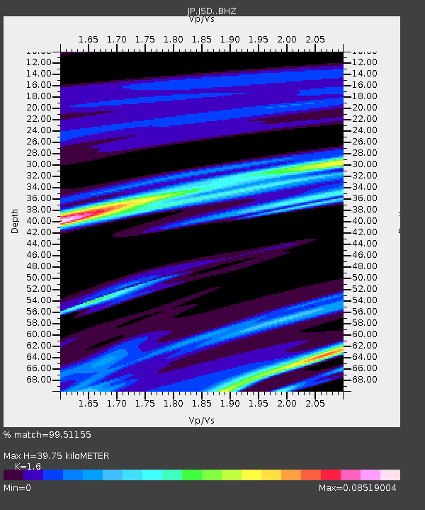
JSD Sado - Earthquake Result Viewer
| Earthquake location: |
Mindanao, Philippines |
| Earthquake latitude/longitude: |
5.7/125.2 |
| Earthquake time(UTC): |
2021/08/27 (239) 10:22:26 GMT |
| Earthquake Depth: |
39 km |
| Earthquake Magnitude: |
5.6 Mww |
| Earthquake Catalog/Contributor: |
NEIC PDE/us |
|
| Network: |
JP Japan Meteorological Agency Seismic Network |
| Station: |
JSD Sado |
| Lat/Lon: |
38.04 N/138.26 E |
| Elevation: |
146 m |
|
| Distance: |
34.3 deg |
| Az: |
18.402 deg |
| Baz: |
203.444 deg |
| Ray Param: |
0.07774277 |
| Estimated Moho Depth: |
39.75 km |
| Estimated Crust Vp/Vs: |
1.60 |
| Assumed Crust Vp: |
6.183 km/s |
| Estimated Crust Vs: |
3.864 km/s |
| Estimated Crust Poisson's Ratio: |
0.18 |
|
| Radial Match: |
99.51155 % |
| Radial Bump: |
84 |
| Transverse Match: |
99.14785 % |
| Transverse Bump: |
132 |
| SOD ConfigId: |
25131211 |
| Insert Time: |
2021-09-10 10:32:46.204 +0000 |
| GWidth: |
2.5 |
| Max Bumps: |
400 |
| Tol: |
0.001 |
|

Signal To Noise
| Channel | StoN | STA | LTA |
| JP:JSD: :BHZ:20210827T10:28:38.649997Z | 3.1389086 | 5.1886296E-8 | 1.6530043E-8 |
| JP:JSD: :BHN:20210827T10:28:38.649997Z | 3.10612 | 5.1775505E-8 | 1.6668867E-8 |
| JP:JSD: :BHE:20210827T10:28:38.649997Z | 3.1144583 | 5.1342106E-8 | 1.6485084E-8 |
| Arrivals |
| Ps | 4.2 SECOND |
| PpPs | 15 SECOND |
| PsPs/PpSs | 20 SECOND |


