You are here: Home > Network List > YL01 - Himalayan Nepal Tibet Experiment Stations List
> Station ILAM YL.ILAM > Earthquake Result Viewer
ILAM YL.ILAM - Earthquake Result Viewer
| Earthquake location: |
Vanuatu Islands |
| Earthquake latitude/longitude: |
-14.6/167.3 |
| Earthquake time(UTC): |
2001/12/27 (361) 10:54:51 GMT |
| Earthquake Depth: |
153 km |
| Earthquake Magnitude: |
5.7 MB, 6.2 MW, 6.1 MW |
| Earthquake Catalog/Contributor: |
WHDF/NEIC |
|
| Network: |
YL Himalayan Nepal Tibet Experiment |
| Station: |
ILAM YL.ILAM |
| Lat/Lon: |
26.91 N/87.92 E |
| Elevation: |
1181 m |
|
| Distance: |
87.3 deg |
| Az: |
298.54 deg |
| Baz: |
107.777 deg |
| Ray Param: |
0.043069262 |
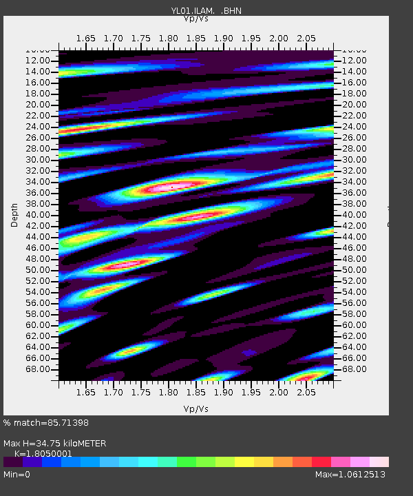
| Estimated Moho Depth: |
34.75 km |
| Estimated Crust Vp/Vs: |
1.81 |
| Assumed Crust Vp: |
6.236 km/s |
| Estimated Crust Vs: |
3.455 km/s |
| Estimated Crust Poisson's Ratio: |
0.28 |
|
| Radial Match: |
85.71398 % |
| Radial Bump: |
400 |
| Transverse Match: |
83.30847 % |
| Transverse Bump: |
400 |
| SOD ConfigId: |
16820 |
| Insert Time: |
2010-02-26 15:55:31.824 +0000 |
| GWidth: |
2.5 |
| Max Bumps: |
400 |
| Tol: |
0.001 |
|
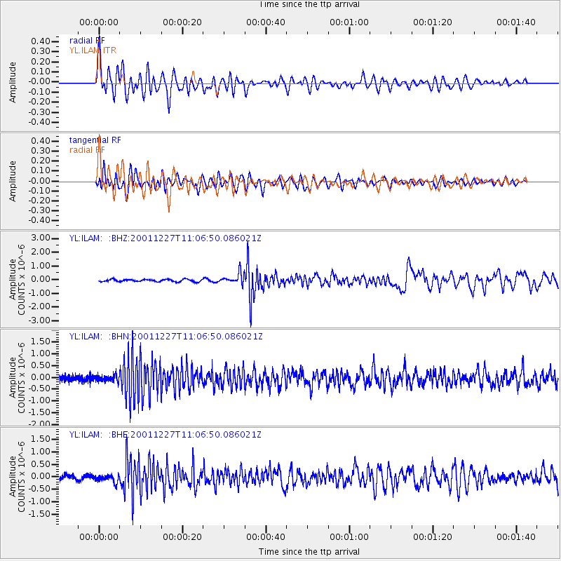
Signal To Noise
| Channel | StoN | STA | LTA |
| YL:ILAM: :BHN:20011227T11:06:50.086021Z | 1.1586905 | 1.3424248E-7 | 1.1585708E-7 |
| YL:ILAM: :BHE:20011227T11:06:50.086021Z | 1.8242563 | 1.536259E-7 | 8.42129E-8 |
| YL:ILAM: :BHZ:20011227T11:06:50.086021Z | 4.9764357 | 4.08235E-7 | 8.2033615E-8 |
| Arrivals |
| Ps | 4.6 SECOND |
| PpPs | 15 SECOND |
| PsPs/PpSs | 20 SECOND |


