You are here: Home > Network List > US - United States National Seismic Network Stations List
> Station HAWA Hanford, Washington, USA > Earthquake Result Viewer
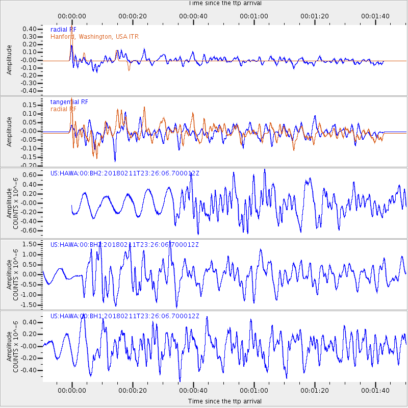
HAWA Hanford, Washington, USA - Earthquake Result Viewer
*The percent match for this event was below the threshold and hence no stack was calculated.
| Earthquake location: |
South Of Mariana Islands |
| Earthquake latitude/longitude: |
13.8/146.5 |
| Earthquake time(UTC): |
2018/02/11 (042) 23:14:18 GMT |
| Earthquake Depth: |
42 km |
| Earthquake Magnitude: |
6.2 Mi |
| Earthquake Catalog/Contributor: |
NEIC PDE/pt |
|
| Network: |
US United States National Seismic Network |
| Station: |
HAWA Hanford, Washington, USA |
| Lat/Lon: |
46.39 N/119.53 W |
| Elevation: |
364 m |
|
| Distance: |
82.8 deg |
| Az: |
44.105 deg |
| Baz: |
282.38 deg |
| Ray Param: |
$rayparam |
*The percent match for this event was below the threshold and hence was not used in the summary stack. |
|
| Radial Match: |
67.69018 % |
| Radial Bump: |
400 |
| Transverse Match: |
66.661285 % |
| Transverse Bump: |
400 |
| SOD ConfigId: |
2546091 |
| Insert Time: |
2018-02-25 23:18:56.166 +0000 |
| GWidth: |
2.5 |
| Max Bumps: |
400 |
| Tol: |
0.001 |
|
Signal To Noise
| Channel | StoN | STA | LTA |
| US:HAWA:00:BHZ:20180211T23:26:06.700012Z | 1.096034 | 3.2092288E-7 | 2.9280378E-7 |
| US:HAWA:00:BH1:20180211T23:26:06.700012Z | 2.9904277 | 2.93837E-7 | 9.8259186E-8 |
| US:HAWA:00:BH2:20180211T23:26:06.700012Z | 1.5075353 | 2.5250247E-7 | 1.6749357E-7 |
| Arrivals |
| Ps | |
| PpPs | |
| PsPs/PpSs | |


