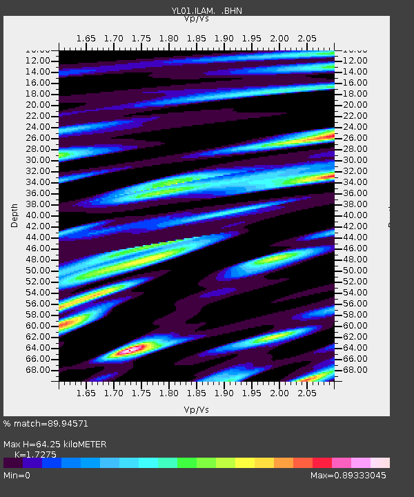
ILAM YL.ILAM - Earthquake Result Viewer
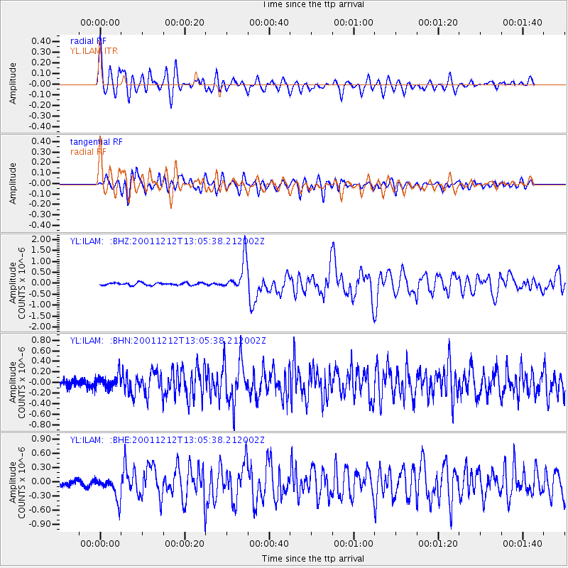
Earthquake location: Vanuatu Islands
Earthquake latitude/longitude: -17.2/167.7
Earthquake time(UTC): 2001/12/12 (346) 12:53:18 GMT
Earthquake Depth: 33 km
Earthquake Magnitude: 6.0 MB, 6.0 MS, 6.2 MW, 6.2 MW
Earthquake Catalog/Contributor: WHDF/NEIC
Network: YL Himalayan Nepal Tibet Experiment
Station: ILAM YL.ILAM
Lat/Lon: 26.91 N/87.92 E
Elevation: 1181 m
Distance: 88.9 deg
Az: 298.481 deg
Baz: 109.788 deg
Ray Param: 0.042190854
Estimated Moho Depth: 64.25 km
Estimated Crust Vp/Vs: 1.73
Assumed Crust Vp: 6.236 km/s
Estimated Crust Vs: 3.61 km/s
Estimated Crust Poisson's Ratio: 0.25
Radial Match: 89.94571 %
Radial Bump: 400
Transverse Match: 86.63938 %
Transverse Bump: 400
SOD ConfigId: 16820
Insert Time: 2010-02-26 15:55:36.837 +0000
GWidth: 2.5
Max Bumps: 400
Tol: 0.001

Signal To Noise

ChannelStoNSTALTA
YL:ILAM: :BHN:20011212T13:05:38.212002Z1.96279851.3096664E-76.6724446E-8
YL:ILAM: :BHE:20011212T13:05:38.212002Z3.5110982.399798E-76.8348946E-8
YL:ILAM: :BHZ:20011212T13:05:38.212002Z13.5406737.42162E-75.480983E-8
Arrivals
Ps7.7 SECOND
PpPs28 SECOND
PsPs/PpSs35 SECOND