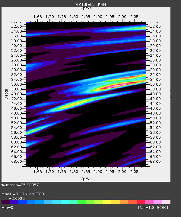
ILAM YL.ILAM - Earthquake Result Viewer
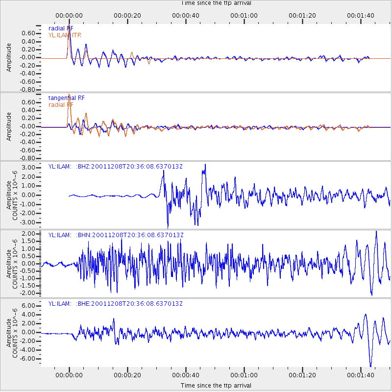
Earthquake location: Ryukyu Islands, Japan
Earthquake latitude/longitude: 28.3/129.6
Earthquake time(UTC): 2001/12/08 (342) 20:29:34 GMT
Earthquake Depth: 33 km
Earthquake Magnitude: 5.7 MB, 5.7 MS, 6.2 MW, 6.1 MW
Earthquake Catalog/Contributor: WHDF/NEIC
Network: YL Himalayan Nepal Tibet Experiment
Station: ILAM YL.ILAM
Lat/Lon: 26.91 N/87.92 E
Elevation: 1181 m
Distance: 36.8 deg
Az: 277.96 deg
Baz: 78.086 deg
Ray Param: 0.076414764
Estimated Moho Depth: 33.0 km
Estimated Crust Vp/Vs: 2.00
Assumed Crust Vp: 6.236 km/s
Estimated Crust Vs: 3.114 km/s
Estimated Crust Poisson's Ratio: 0.33
Radial Match: 85.98957 %
Radial Bump: 400
Transverse Match: 65.20718 %
Transverse Bump: 400
SOD ConfigId: 16820
Insert Time: 2010-02-26 15:55:37.967 +0000
GWidth: 2.5
Max Bumps: 400
Tol: 0.001

Signal To Noise

ChannelStoNSTALTA
YL:ILAM: :BHN:20011208T20:36:08.637013Z3.73136263.1208907E-78.363944E-8
YL:ILAM: :BHE:20011208T20:36:08.637013Z16.9639177.098621E-74.184541E-8
YL:ILAM: :BHZ:20011208T20:36:08.637013Z19.8615761.2702798E-66.395665E-8
Arrivals
Ps5.6 SECOND
PpPs15 SECOND
PsPs/PpSs21 SECOND