You are here: Home > Network List > G - GEOSCOPE Stations List
> Station NOUC Port Laguerre, New Caledonia > Earthquake Result Viewer
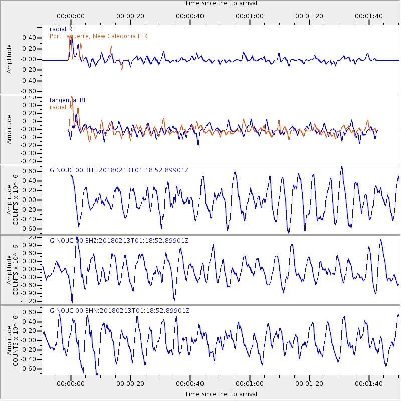
NOUC Port Laguerre, New Caledonia - Earthquake Result Viewer
*The percent match for this event was below the threshold and hence no stack was calculated.
| Earthquake location: |
South Of Mariana Islands |
| Earthquake latitude/longitude: |
13.9/146.4 |
| Earthquake time(UTC): |
2018/02/13 (044) 01:11:43 GMT |
| Earthquake Depth: |
12 km |
| Earthquake Magnitude: |
5.4 mb |
| Earthquake Catalog/Contributor: |
NEIC PDE/us |
|
| Network: |
G GEOSCOPE |
| Station: |
NOUC Port Laguerre, New Caledonia |
| Lat/Lon: |
22.10 S/166.30 E |
| Elevation: |
112 m |
|
| Distance: |
40.7 deg |
| Az: |
151.057 deg |
| Baz: |
329.546 deg |
| Ray Param: |
$rayparam |
*The percent match for this event was below the threshold and hence was not used in the summary stack. |
|
| Radial Match: |
55.46625 % |
| Radial Bump: |
400 |
| Transverse Match: |
50.5843 % |
| Transverse Bump: |
400 |
| SOD ConfigId: |
2546091 |
| Insert Time: |
2018-02-27 01:12:35.486 +0000 |
| GWidth: |
2.5 |
| Max Bumps: |
400 |
| Tol: |
0.001 |
|
Signal To Noise
| Channel | StoN | STA | LTA |
| G:NOUC:00:BHZ:20180213T01:18:52.89901Z | 4.8596735 | 7.041908E-7 | 1.4490497E-7 |
| G:NOUC:00:BHN:20180213T01:18:52.89901Z | 1.8869942 | 3.4366812E-7 | 1.8212462E-7 |
| G:NOUC:00:BHE:20180213T01:18:52.89901Z | 1.2400737 | 2.622968E-7 | 2.1151712E-7 |
| Arrivals |
| Ps | |
| PpPs | |
| PsPs/PpSs | |


