You are here: Home > Network List > TC - Red Sismólogica Nacional de Costa Rica Stations List
> Station MARA Maravilla > Earthquake Result Viewer
MARA Maravilla - Earthquake Result Viewer
| Earthquake location: |
South Sandwich Islands Region |
| Earthquake latitude/longitude: |
-58.1/-23.5 |
| Earthquake time(UTC): |
2021/08/29 (241) 23:32:44 GMT |
| Earthquake Depth: |
10 km |
| Earthquake Magnitude: |
5.3 Mww |
| Earthquake Catalog/Contributor: |
NEIC PDE/us |
|
| Network: |
TC Red Sismólogica Nacional de Costa Rica |
| Station: |
MARA Maravilla |
| Lat/Lon: |
10.02 N/85.43 W |
| Elevation: |
629 m |
|
| Distance: |
84.3 deg |
| Az: |
299.172 deg |
| Baz: |
151.919 deg |
| Ray Param: |
0.04560609 |
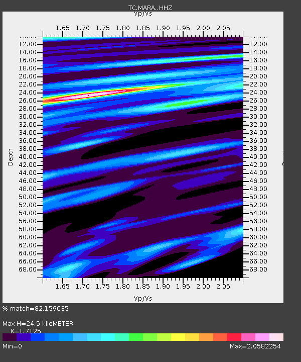
| Estimated Moho Depth: |
24.5 km |
| Estimated Crust Vp/Vs: |
1.71 |
| Assumed Crust Vp: |
6.597 km/s |
| Estimated Crust Vs: |
3.853 km/s |
| Estimated Crust Poisson's Ratio: |
0.24 |
|
| Radial Match: |
82.159035 % |
| Radial Bump: |
400 |
| Transverse Match: |
73.97791 % |
| Transverse Bump: |
400 |
| SOD ConfigId: |
25131211 |
| Insert Time: |
2021-09-12 23:36:52.623 +0000 |
| GWidth: |
2.5 |
| Max Bumps: |
400 |
| Tol: |
0.001 |
|

Signal To Noise
| Channel | StoN | STA | LTA |
| TC:MARA: :HHZ:20210829T23:44:44.839983Z | 2.6093645 | 1.6187184E-6 | 6.203497E-7 |
| TC:MARA: :HHN:20210829T23:44:44.839983Z | 2.584741 | 1.7808114E-6 | 6.8897094E-7 |
| TC:MARA: :HHE:20210829T23:44:44.839983Z | 1.2659507 | 1.693542E-6 | 1.337763E-6 |
| Arrivals |
| Ps | 2.7 SECOND |
| PpPs | 9.8 SECOND |
| PsPs/PpSs | 13 SECOND |


