You are here: Home > Network List > AK - Alaska Regional Network Stations List
> Station UNV Unalaska Valley > Earthquake Result Viewer
UNV Unalaska Valley - Earthquake Result Viewer
| Earthquake location: |
Kermadec Islands Region |
| Earthquake latitude/longitude: |
-30.1/-176.6 |
| Earthquake time(UTC): |
2021/08/31 (243) 02:52:49 GMT |
| Earthquake Depth: |
40 km |
| Earthquake Magnitude: |
6.5 Mi |
| Earthquake Catalog/Contributor: |
NEIC PDE/at |
|
| Network: |
AK Alaska Regional Network |
| Station: |
UNV Unalaska Valley |
| Lat/Lon: |
53.85 N/166.50 W |
| Elevation: |
67 m |
|
| Distance: |
84.1 deg |
| Az: |
5.996 deg |
| Baz: |
188.787 deg |
| Ray Param: |
0.0456934 |
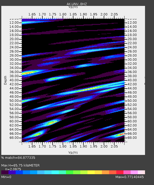
| Estimated Moho Depth: |
65.75 km |
| Estimated Crust Vp/Vs: |
2.10 |
| Assumed Crust Vp: |
3.943 km/s |
| Estimated Crust Vs: |
1.88 km/s |
| Estimated Crust Poisson's Ratio: |
0.35 |
|
| Radial Match: |
84.877335 % |
| Radial Bump: |
400 |
| Transverse Match: |
80.23341 % |
| Transverse Bump: |
400 |
| SOD ConfigId: |
25131211 |
| Insert Time: |
2021-09-14 02:54:39.897 +0000 |
| GWidth: |
2.5 |
| Max Bumps: |
400 |
| Tol: |
0.001 |
|

Signal To Noise
| Channel | StoN | STA | LTA |
| AK:UNV: :BHZ:20210831T03:04:44.288025Z | 2.2774262 | 4.6188418E-7 | 2.0280972E-7 |
| AK:UNV: :BHN:20210831T03:04:44.288025Z | 1.4937699 | 2.5197122E-7 | 1.6868141E-7 |
| AK:UNV: :BHE:20210831T03:04:44.288025Z | 1.148756 | 1.7113325E-7 | 1.4897267E-7 |
| Arrivals |
| Ps | 18 SECOND |
| PpPs | 51 SECOND |
| PsPs/PpSs | 70 SECOND |


