You are here: Home > Network List > AV - Alaska Volcano Observatory Stations List
> Station ETKA Kagalaska Island, Regional Station, Alaska > Earthquake Result Viewer
ETKA Kagalaska Island, Regional Station, Alaska - Earthquake Result Viewer
| Earthquake location: |
Kermadec Islands Region |
| Earthquake latitude/longitude: |
-30.1/-176.6 |
| Earthquake time(UTC): |
2021/08/31 (243) 02:52:49 GMT |
| Earthquake Depth: |
40 km |
| Earthquake Magnitude: |
6.5 Mi |
| Earthquake Catalog/Contributor: |
NEIC PDE/at |
|
| Network: |
AV Alaska Volcano Observatory |
| Station: |
ETKA Kagalaska Island, Regional Station, Alaska |
| Lat/Lon: |
51.86 N/176.41 W |
| Elevation: |
290 m |
|
| Distance: |
81.6 deg |
| Az: |
0.12 deg |
| Baz: |
180.168 deg |
| Ray Param: |
0.047410972 |
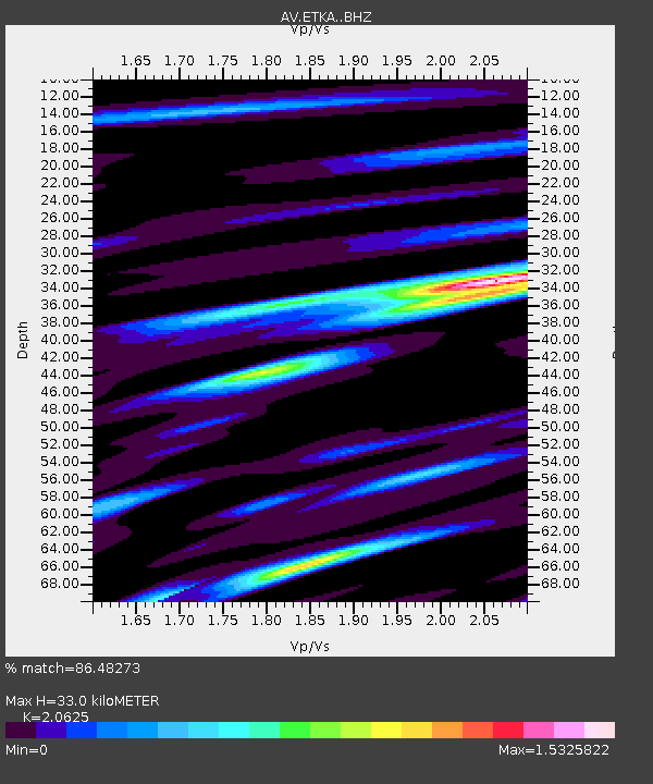
| Estimated Moho Depth: |
33.0 km |
| Estimated Crust Vp/Vs: |
2.06 |
| Assumed Crust Vp: |
5.88 km/s |
| Estimated Crust Vs: |
2.851 km/s |
| Estimated Crust Poisson's Ratio: |
0.35 |
|
| Radial Match: |
86.48273 % |
| Radial Bump: |
397 |
| Transverse Match: |
82.8897 % |
| Transverse Bump: |
400 |
| SOD ConfigId: |
25131211 |
| Insert Time: |
2021-09-14 02:55:47.382 +0000 |
| GWidth: |
2.5 |
| Max Bumps: |
400 |
| Tol: |
0.001 |
|

Signal To Noise
| Channel | StoN | STA | LTA |
| AV:ETKA: :BHZ:20210831T03:04:31.658997Z | 4.1719427 | 7.23712E-7 | 1.7347121E-7 |
| AV:ETKA: :BHN:20210831T03:04:31.658997Z | 1.373343 | 3.1560097E-7 | 2.2980491E-7 |
| AV:ETKA: :BHE:20210831T03:04:31.658997Z | 0.59257543 | 1.0033416E-7 | 1.6931881E-7 |
| Arrivals |
| Ps | 6.1 SECOND |
| PpPs | 17 SECOND |
| PsPs/PpSs | 23 SECOND |


