You are here: Home > Network List > AV - Alaska Volcano Observatory Stations List
> Station GSCK Cape Kiugilak, Great Sitkin Volcano, Alaska > Earthquake Result Viewer
GSCK Cape Kiugilak, Great Sitkin Volcano, Alaska - Earthquake Result Viewer
| Earthquake location: |
Kermadec Islands Region |
| Earthquake latitude/longitude: |
-30.1/-176.6 |
| Earthquake time(UTC): |
2021/08/31 (243) 02:52:49 GMT |
| Earthquake Depth: |
40 km |
| Earthquake Magnitude: |
6.5 Mi |
| Earthquake Catalog/Contributor: |
NEIC PDE/at |
|
| Network: |
AV Alaska Volcano Observatory |
| Station: |
GSCK Cape Kiugilak, Great Sitkin Volcano, Alaska |
| Lat/Lon: |
52.01 N/176.16 W |
| Elevation: |
384 m |
|
| Distance: |
81.8 deg |
| Az: |
0.272 deg |
| Baz: |
180.382 deg |
| Ray Param: |
0.047303326 |
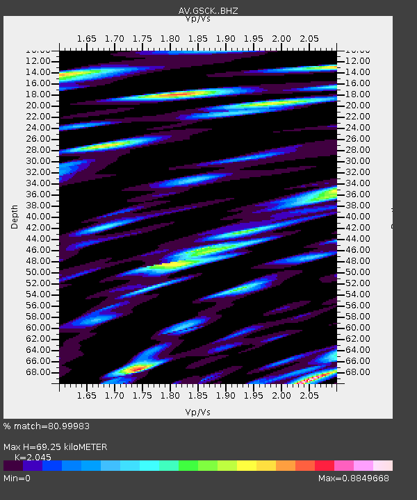
| Estimated Moho Depth: |
69.25 km |
| Estimated Crust Vp/Vs: |
2.05 |
| Assumed Crust Vp: |
3.912 km/s |
| Estimated Crust Vs: |
1.913 km/s |
| Estimated Crust Poisson's Ratio: |
0.34 |
|
| Radial Match: |
80.99983 % |
| Radial Bump: |
400 |
| Transverse Match: |
78.08581 % |
| Transverse Bump: |
400 |
| SOD ConfigId: |
25131211 |
| Insert Time: |
2021-09-14 02:55:52.029 +0000 |
| GWidth: |
2.5 |
| Max Bumps: |
400 |
| Tol: |
0.001 |
|

Signal To Noise
| Channel | StoN | STA | LTA |
| AV:GSCK: :BHZ:20210831T03:04:32.460022Z | 3.1882463 | 4.800056E-7 | 1.5055475E-7 |
| AV:GSCK: :BHN:20210831T03:04:32.460022Z | 0.9780375 | 2.2806925E-7 | 2.3319072E-7 |
| AV:GSCK: :BHE:20210831T03:04:32.460022Z | 0.9859303 | 1.999236E-7 | 2.027766E-7 |
| Arrivals |
| Ps | 19 SECOND |
| PpPs | 53 SECOND |
| PsPs/PpSs | 72 SECOND |


