You are here: Home > Network List > AV - Alaska Volcano Observatory Stations List
> Station KINC North Cape, Kanaga Volcano, Alaska > Earthquake Result Viewer
KINC North Cape, Kanaga Volcano, Alaska - Earthquake Result Viewer
| Earthquake location: |
Kermadec Islands Region |
| Earthquake latitude/longitude: |
-30.1/-176.6 |
| Earthquake time(UTC): |
2021/08/31 (243) 02:52:49 GMT |
| Earthquake Depth: |
40 km |
| Earthquake Magnitude: |
6.5 Mi |
| Earthquake Catalog/Contributor: |
NEIC PDE/at |
|
| Network: |
AV Alaska Volcano Observatory |
| Station: |
KINC North Cape, Kanaga Volcano, Alaska |
| Lat/Lon: |
51.93 N/177.13 W |
| Elevation: |
198 m |
|
| Distance: |
81.7 deg |
| Az: |
359.669 deg |
| Baz: |
179.536 deg |
| Ray Param: |
0.047360588 |
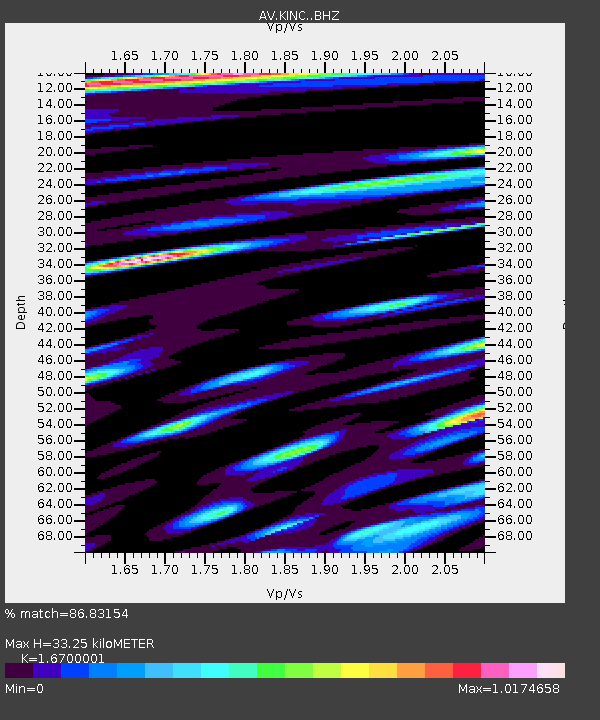
| Estimated Moho Depth: |
33.25 km |
| Estimated Crust Vp/Vs: |
1.67 |
| Assumed Crust Vp: |
5.88 km/s |
| Estimated Crust Vs: |
3.521 km/s |
| Estimated Crust Poisson's Ratio: |
0.22 |
|
| Radial Match: |
86.83154 % |
| Radial Bump: |
400 |
| Transverse Match: |
84.22091 % |
| Transverse Bump: |
400 |
| SOD ConfigId: |
25131211 |
| Insert Time: |
2021-09-14 02:56:08.858 +0000 |
| GWidth: |
2.5 |
| Max Bumps: |
400 |
| Tol: |
0.001 |
|

Signal To Noise
| Channel | StoN | STA | LTA |
| AV:KINC: :BHZ:20210831T03:04:32.039978Z | 2.9739177 | 4.656131E-7 | 1.5656558E-7 |
| AV:KINC: :BHN:20210831T03:04:32.039978Z | 1.1207145 | 2.0815108E-7 | 1.8573068E-7 |
| AV:KINC: :BHE:20210831T03:04:32.039978Z | 1.0891502 | 1.9616492E-7 | 1.8010823E-7 |
| Arrivals |
| Ps | 3.9 SECOND |
| PpPs | 15 SECOND |
| PsPs/PpSs | 19 SECOND |


