You are here: Home > Network List > YL01 - Himalayan Nepal Tibet Experiment Stations List
> Station ILAM YL.ILAM > Earthquake Result Viewer
ILAM YL.ILAM - Earthquake Result Viewer
| Earthquake location: |
Santa Cruz Islands |
| Earthquake latitude/longitude: |
-12.7/166.7 |
| Earthquake time(UTC): |
2001/12/02 (336) 02:47:56 GMT |
| Earthquake Depth: |
100 km |
| Earthquake Magnitude: |
5.8 MB, 6.0 MW, 6.0 MW |
| Earthquake Catalog/Contributor: |
WHDF/NEIC |
|
| Network: |
YL Himalayan Nepal Tibet Experiment |
| Station: |
ILAM YL.ILAM |
| Lat/Lon: |
26.91 N/87.92 E |
| Elevation: |
1181 m |
|
| Distance: |
85.9 deg |
| Az: |
298.598 deg |
| Baz: |
106.386 deg |
| Ray Param: |
0.04422392 |
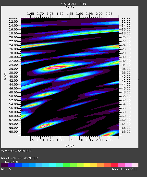
| Estimated Moho Depth: |
64.75 km |
| Estimated Crust Vp/Vs: |
1.72 |
| Assumed Crust Vp: |
6.236 km/s |
| Estimated Crust Vs: |
3.636 km/s |
| Estimated Crust Poisson's Ratio: |
0.24 |
|
| Radial Match: |
92.91982 % |
| Radial Bump: |
400 |
| Transverse Match: |
86.54464 % |
| Transverse Bump: |
400 |
| SOD ConfigId: |
16820 |
| Insert Time: |
2010-02-26 15:55:40.930 +0000 |
| GWidth: |
2.5 |
| Max Bumps: |
400 |
| Tol: |
0.001 |
|
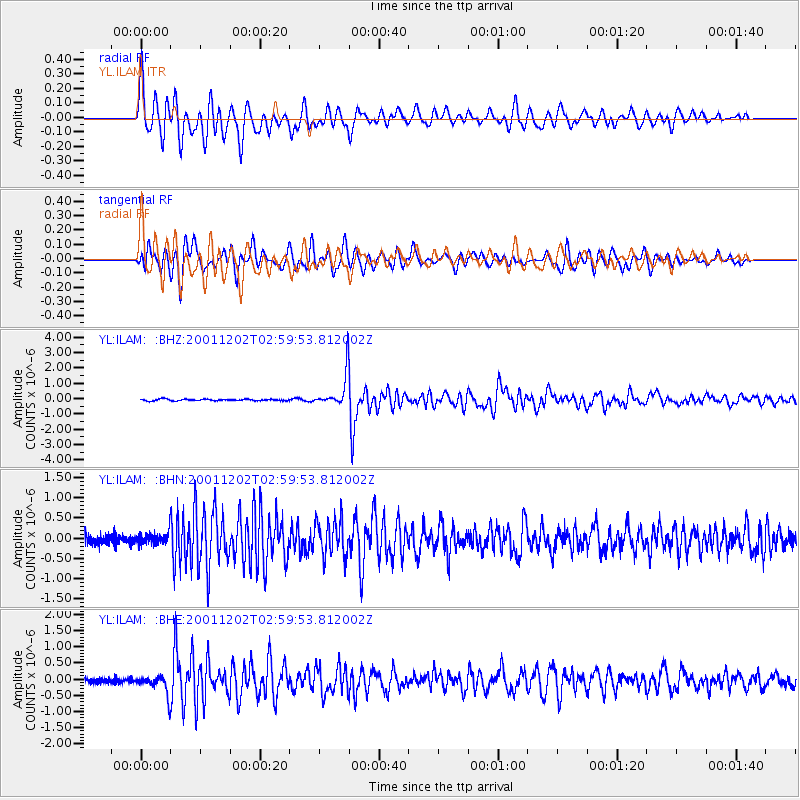
Signal To Noise
| Channel | StoN | STA | LTA |
| YL:ILAM: :BHN:20011202T02:59:53.812002Z | 1.4084473 | 1.3720343E-7 | 9.741467E-8 |
| YL:ILAM: :BHE:20011202T02:59:53.812002Z | 4.9362507 | 2.918563E-7 | 5.91251E-8 |
| YL:ILAM: :BHZ:20011202T02:59:53.812002Z | 21.495346 | 1.0951575E-6 | 5.0948582E-8 |
| Arrivals |
| Ps | 7.6 SECOND |
| PpPs | 28 SECOND |
| PsPs/PpSs | 35 SECOND |


