You are here: Home > Network List > AV - Alaska Volcano Observatory Stations List
> Station P18K Big Mountain, AK, USA > Earthquake Result Viewer
P18K Big Mountain, AK, USA - Earthquake Result Viewer
| Earthquake location: |
Kermadec Islands Region |
| Earthquake latitude/longitude: |
-30.1/-176.6 |
| Earthquake time(UTC): |
2021/08/31 (243) 02:52:49 GMT |
| Earthquake Depth: |
40 km |
| Earthquake Magnitude: |
6.5 Mi |
| Earthquake Catalog/Contributor: |
NEIC PDE/at |
|
| Network: |
AV Alaska Volcano Observatory |
| Station: |
P18K Big Mountain, AK, USA |
| Lat/Lon: |
59.39 N/155.23 W |
| Elevation: |
680 m |
|
| Distance: |
90.9 deg |
| Az: |
10.748 deg |
| Baz: |
198.411 deg |
| Ray Param: |
0.041658696 |
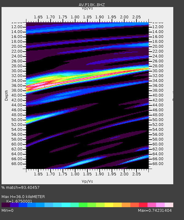
| Estimated Moho Depth: |
36.0 km |
| Estimated Crust Vp/Vs: |
1.68 |
| Assumed Crust Vp: |
6.438 km/s |
| Estimated Crust Vs: |
3.844 km/s |
| Estimated Crust Poisson's Ratio: |
0.22 |
|
| Radial Match: |
93.40457 % |
| Radial Bump: |
400 |
| Transverse Match: |
87.6955 % |
| Transverse Bump: |
400 |
| SOD ConfigId: |
25131211 |
| Insert Time: |
2021-09-14 02:56:27.963 +0000 |
| GWidth: |
2.5 |
| Max Bumps: |
400 |
| Tol: |
0.001 |
|

Signal To Noise
| Channel | StoN | STA | LTA |
| AV:P18K: :BHZ:20210831T03:05:17.224976Z | 1.1329471 | 5.346312E-8 | 4.718942E-8 |
| AV:P18K: :BHN:20210831T03:05:17.224976Z | 1.0908887 | 4.5345782E-8 | 4.1567745E-8 |
| AV:P18K: :BHE:20210831T03:05:17.224976Z | 1.9186882 | 6.5726816E-8 | 3.425612E-8 |
| Arrivals |
| Ps | 3.9 SECOND |
| PpPs | 15 SECOND |
| PsPs/PpSs | 18 SECOND |


