You are here: Home > Network List > AV - Alaska Volcano Observatory Stations List
> Station TAFP Falls Point, Tanaga Volcano, Alaska > Earthquake Result Viewer
TAFP Falls Point, Tanaga Volcano, Alaska - Earthquake Result Viewer
| Earthquake location: |
Kermadec Islands Region |
| Earthquake latitude/longitude: |
-30.1/-176.6 |
| Earthquake time(UTC): |
2021/08/31 (243) 02:52:49 GMT |
| Earthquake Depth: |
40 km |
| Earthquake Magnitude: |
6.5 Mi |
| Earthquake Catalog/Contributor: |
NEIC PDE/at |
|
| Network: |
AV Alaska Volcano Observatory |
| Station: |
TAFP Falls Point, Tanaga Volcano, Alaska |
| Lat/Lon: |
51.90 N/177.99 W |
| Elevation: |
440 m |
|
| Distance: |
81.7 deg |
| Az: |
359.133 deg |
| Baz: |
178.787 deg |
| Ray Param: |
0.0473774 |
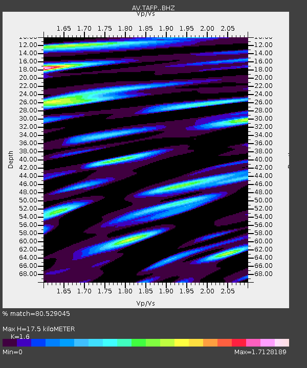
| Estimated Moho Depth: |
17.5 km |
| Estimated Crust Vp/Vs: |
1.60 |
| Assumed Crust Vp: |
5.88 km/s |
| Estimated Crust Vs: |
3.675 km/s |
| Estimated Crust Poisson's Ratio: |
0.18 |
|
| Radial Match: |
80.529045 % |
| Radial Bump: |
400 |
| Transverse Match: |
81.38689 % |
| Transverse Bump: |
400 |
| SOD ConfigId: |
25131211 |
| Insert Time: |
2021-09-14 02:56:43.271 +0000 |
| GWidth: |
2.5 |
| Max Bumps: |
400 |
| Tol: |
0.001 |
|

Signal To Noise
| Channel | StoN | STA | LTA |
| AV:TAFP: :BHZ:20210831T03:04:31.919983Z | 4.123141 | 4.7006057E-7 | 1.1400546E-7 |
| AV:TAFP: :BHN:20210831T03:04:31.919983Z | 0.670342 | 1.2027465E-7 | 1.7942281E-7 |
| AV:TAFP: :BHE:20210831T03:04:31.919983Z | 0.8987602 | 1.7126884E-7 | 1.9056121E-7 |
| Arrivals |
| Ps | 1.8 SECOND |
| PpPs | 7.5 SECOND |
| PsPs/PpSs | 9.4 SECOND |


