You are here: Home > Network List > IU - Global Seismograph Network (GSN - IRIS/USGS) Stations List
> Station INCN Inchon, Republic of Korea > Earthquake Result Viewer
INCN Inchon, Republic of Korea - Earthquake Result Viewer

| Earthquake location: |
Kermadec Islands Region |
| Earthquake latitude/longitude: |
-30.1/-176.6 |
| Earthquake time(UTC): |
2021/08/31 (243) 02:52:49 GMT |
| Earthquake Depth: |
40 km |
| Earthquake Magnitude: |
6.5 Mi |
| Earthquake Catalog/Contributor: |
NEIC PDE/at |
|
| Network: |
IU Global Seismograph Network (GSN - IRIS/USGS) |
| Station: |
INCN Inchon, Republic of Korea |
| Lat/Lon: |
37.48 N/126.62 E |
| Elevation: |
55 m |
|
| Distance: |
85.7 deg |
| Az: |
318.132 deg |
| Baz: |
133.363 deg |
| Ray Param: |
0.044536285 |
| Estimated Moho Depth: |
30.5 km |
| Estimated Crust Vp/Vs: |
1.77 |
| Assumed Crust Vp: |
6.459 km/s |
| Estimated Crust Vs: |
3.649 km/s |
| Estimated Crust Poisson's Ratio: |
0.27 |
|
| Radial Match: |
97.402695 % |
| Radial Bump: |
306 |
| Transverse Match: |
86.87829 % |
| Transverse Bump: |
400 |
| SOD ConfigId: |
25131211 |
| Insert Time: |
2021-09-14 03:01:37.184 +0000 |
| GWidth: |
2.5 |
| Max Bumps: |
400 |
| Tol: |
0.001 |
|
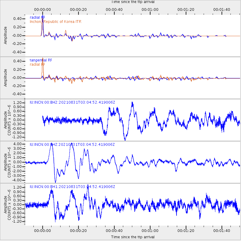
Signal To Noise
| Channel | StoN | STA | LTA |
| IU:INCN:00:BHZ:20210831T03:04:52.419006Z | 15.179245 | 1.541573E-6 | 1.0155795E-7 |
| IU:INCN:00:BH1:20210831T03:04:52.419006Z | 3.6059582 | 3.973277E-7 | 1.1018644E-7 |
| IU:INCN:00:BH2:20210831T03:04:52.419006Z | 3.3623562 | 3.8177043E-7 | 1.13542534E-7 |
| Arrivals |
| Ps | 3.7 SECOND |
| PpPs | 13 SECOND |
| PsPs/PpSs | 16 SECOND |


