You are here: Home > Network List > NN - Western Great Basin/Eastern Sierra Nevada Stations List
> Station ZPR Zephyr Cove, Lake Tahoe, Nevada > Earthquake Result Viewer
ZPR Zephyr Cove, Lake Tahoe, Nevada - Earthquake Result Viewer
| Earthquake location: |
Kermadec Islands Region |
| Earthquake latitude/longitude: |
-30.1/-176.6 |
| Earthquake time(UTC): |
2021/08/31 (243) 02:52:49 GMT |
| Earthquake Depth: |
40 km |
| Earthquake Magnitude: |
6.5 Mi |
| Earthquake Catalog/Contributor: |
NEIC PDE/at |
|
| Network: |
NN Western Great Basin/Eastern Sierra Nevada |
| Station: |
ZPR Zephyr Cove, Lake Tahoe, Nevada |
| Lat/Lon: |
39.01 N/119.94 W |
| Elevation: |
2001 m |
|
| Distance: |
86.7 deg |
| Az: |
40.69 deg |
| Baz: |
226.488 deg |
| Ray Param: |
0.04383141 |
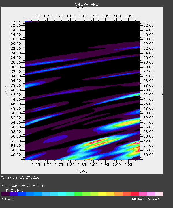
| Estimated Moho Depth: |
62.25 km |
| Estimated Crust Vp/Vs: |
2.10 |
| Assumed Crust Vp: |
6.279 km/s |
| Estimated Crust Vs: |
2.993 km/s |
| Estimated Crust Poisson's Ratio: |
0.35 |
|
| Radial Match: |
83.293236 % |
| Radial Bump: |
275 |
| Transverse Match: |
97.57283 % |
| Transverse Bump: |
113 |
| SOD ConfigId: |
25131211 |
| Insert Time: |
2021-09-14 03:02:55.801 +0000 |
| GWidth: |
2.5 |
| Max Bumps: |
400 |
| Tol: |
0.001 |
|

Signal To Noise
| Channel | StoN | STA | LTA |
| NN:ZPR: :HHZ:20210831T03:04:57.257996Z | 1.5026935 | 8.890642E-8 | 5.9164705E-8 |
| NN:ZPR: :HHN:20210831T03:04:57.257996Z | 1.2651681 | 1.6135603E-7 | 1.2753722E-7 |
| NN:ZPR: :HHE:20210831T03:04:57.257996Z | 1.2643055 | 1.937216E-7 | 1.5322372E-7 |
| Arrivals |
| Ps | 11 SECOND |
| PpPs | 30 SECOND |
| PsPs/PpSs | 41 SECOND |


